Ibieca geodata
Ibieca (Aragon) is a seat of a third-order administrative division; located in Spain in Europe/Madrid (GMT+2) time zone. With population of 120 people, there are 5697 cities with bigger population in this country. Compared to other cities in Spain, 78.2% of cities are located further ↓South; 85.5% of cities are located further ←West and 51.4% of cities have higher elevation than Ibieca. Note1


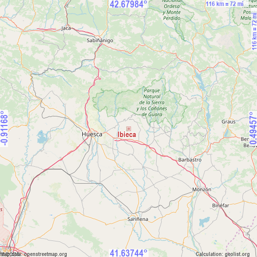
Ibieca GPS coordinates[2]
42° 9' 38.844" North, 0° 12' 30.78" West
| Map corner | latitude | longitude |
|---|---|---|
| Upper-left | 42.67984°, | -0.91168° |
| Center: | 42.16079°, | -0.20855° |
| Lower-right: | 41.63744°, | 0.49457° |
| Map W x H: | 115.9×115.9 km | = 72×72mi |
| max Lat: | 43.74134° ⇑21.8% North |
| Ibieca: | 42.16079° |
| min Lat: | ⇓78.2% South 27.64134° |
| min Long | Ibieca | max Long |
| -18.00367° | -0.20855° | 4.2899° |
| W 85.5%⇐ | ⇒14.5% E |
Elevation
Elevation of Ibieca is 644 m = 2113 ft, and this is 46 m = 151 ft above average elevation for this country.
| Max E: |
1682 m = 5518 ft | 51.4% |
| Ibieca | 644 m 2113 ft | |
| Avg. | 598 m = 1962 ft | |
Min E: |
0 m = 0 ft | 48.6% |
See also: Spain elevation on elevation.city.
Geographical zone
Ibieca is located in North temperate zone (between Tropic of Cancer and the Arctic Circle). Distance of this Northern Tropic circle is 2081.9 km =1293.6 mi to South.| Distance of | km | miles | from Ibieca |
|---|---|---|---|
| North Pole | 5319.2 | 3305.2 | to North |
| Arctic Circle | 2713.3 | 1686 | to North |
| Tropic Cancer | 2081.9 | 1293.6 | to South |
| Equator | 4687.8 | 2912.9 | to South |


Nearby cities:
15 places around Ibieca: (largest is in red/bold)
• Abiego
12.3 km =7.6 mi,  111°
111°
• Adahuesca
16.6 km =10.3 mi,  95°
95°
• Albero Alto
16.2 km =10.1 mi,  220°
220°
• Alcalá del Obispo
11.5 km =7.1 mi, 216°
• Angüés
7.2 km =4.5 mi,  140°
140°
• Antillón
14.3 km =8.9 mi,  164°
164°
• Argavieso
13.3 km =8.3 mi,  205°
205°
• Azlor
15.3 km =9.5 mi,  118°
118°
• Bierge
10.3 km =6.4 mi,  89°
89°
• Casbas de Huesca
5.7 km =3.5 mi, 95°
• Loporzano
9.5 km =5.9 mi,  270°
270°
• Novales
15.7 km =9.8 mi,  204°
204°
• Quicena
12.6 km =7.8 mi,  263°
263°
• Siétamo
7.2 km =4.5 mi,  235°
235°
• Tierz
12.4 km =7.7 mi, 255°
Sources, notices
• [Note1] Compared only with cities in Spain existing in our database
• [Src1] Map data: © OpenStreetMap contributors (CC-BY-SA)
• [Src2] Other city data from geonames.org with taken over terms of usage.
• [Src3] Geographical zone / Annual Mean Temperature by Robert A. Rohde @ Wikipedia
