Loarre geodata
Loarre (Aragon) is a seat of a third-order administrative division; located in Spain in Europe/Madrid (GMT+2) time zone. With population of 412 people, there are 4106 cities with bigger population in this country. Compared to other cities in Spain, 82.1% of cities are located further ↓South; 80.4% of cities are located further ←West and 65.8% of cities have lower elevation than Loarre. Note1


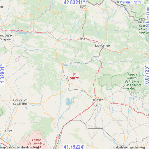
Loarre GPS coordinates[2]
42° 18' 51.552" North, 0° 37' 33.168" West
| Map corner | latitude | longitude |
|---|---|---|
| Upper-left | 42.83211°, | -1.32901° |
| Center: | 42.31432°, | -0.62588° |
| Lower-right: | 41.79224°, | 0.07725° |
| Map W x H: | 115.6×115.6 km | = 71.8×71.8mi |
| max Lat: | 43.74134° ⇑17.9% North |
| Loarre: | 42.31432° |
| min Lat: | ⇓82.1% South 27.64134° |
| min Long | Loarre | max Long |
| -18.00367° | -0.62588° | 4.2899° |
| W 80.4%⇐ | ⇒19.6% E |
Elevation
Elevation of Loarre is 783 m = 2569 ft, and this is 185 m = 607 ft above average elevation for this country.
| Max E: |
1682 m = 5518 ft | 34.2% |
| Loarre | 783 m 2569 ft | |
| Avg. | 598 m = 1962 ft | |
Min E: |
0 m = 0 ft | 65.8% |
See also: Spain elevation on elevation.city.
Geographical zone
Loarre is located in North temperate zone (between Tropic of Cancer and the Arctic Circle). Distance of this Northern Tropic circle is 2099 km =1304.3 mi to South.| Distance of | km | miles | from Loarre |
|---|---|---|---|
| North Pole | 5302.2 | 3294.6 | to North |
| Arctic Circle | 2696.3 | 1675.4 | to North |
| Tropic Cancer | 2099 | 1304.3 | to South |
| Equator | 4704.9 | 2923.5 | to South |


Nearby cities:
15 places around Loarre: (largest is in red/bold)
• Agüero
14.5 km =9 mi,  288°
288°
• Alerre
21.3 km =13.2 mi,  141°
141°
• Arguis
15.3 km =9.5 mi,  89°
89°
• Ayerbe
6.9 km =4.3 mi,  228°
228°
• Bailo
26.5 km =16.5 mi,  324°
324°
• Banastás
20.6 km =12.8 mi, 136°
• Biscarrués
13.9 km =8.6 mi, 226°
• Chimillas
21.5 km =13.4 mi, 138°
• Igriés
19.4 km =12.1 mi,  124°
124°
• Loscorrales
6.8 km =4.2 mi,  191°
191°
• Nueno
16.2 km =10.1 mi,  108°
108°
• Piedratajada
26 km =16.2 mi,  214°
214°
• Santa Cruz de la Serós
23.5 km =14.6 mi,  350°
350°
• Santa Eulalia de Gállego
11.5 km =7.1 mi,  254°
254°
• Valpalmas
25.6 km =15.9 mi, 227°
Sources, notices
• [Note1] Compared only with cities in Spain existing in our database
• [Src1] Map data: © OpenStreetMap contributors (CC-BY-SA)
• [Src2] Other city data from geonames.org with taken over terms of usage.
• [Src3] Geographical zone / Annual Mean Temperature by Robert A. Rohde @ Wikipedia
