Robledillo de Mohernando geodata
Robledillo de Mohernando (Castille-La Mancha) is a seat of a third-order administrative division; located in Spain in Europe/Madrid (GMT+2) time zone. With population of 122 people, there are 5674 cities with bigger population in this country. Compared to other cities in Spain, 54.9% of cities are located further ↑North; 51.3% of cities are located further ←West and 77.4% of cities have lower elevation than Robledillo de Mohernando. Note1
Administrative division(s):
- Level 1: Castille-La Mancha
- Level 2: Provincia de Guadalajara
- Level 3: Robledillo de Mohernando
Current local time in Robledillo de Mohernando:
10:56 PM, ThursdayDifference from your time zone: hours


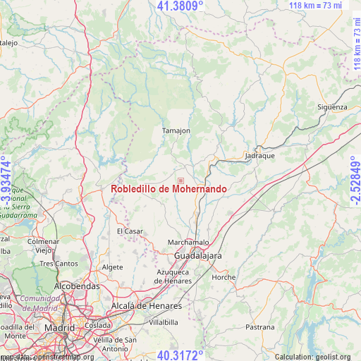
Robledillo de Mohernando GPS coordinates[2]
40° 51' 4.248" North, 3° 13' 53.832" West
| Map corner | latitude | longitude |
|---|---|---|
| Upper-left | 41.3809°, | -3.93474° |
| Center: | 40.85118°, | -3.23162° |
| Lower-right: | 40.3172°, | -2.52849° |
| Map W x H: | 118.3×118.3 km | = 73.5×73.5mi |
| max Lat: | 43.74134° ⇑54.9% North |
| Robledillo de Mohernando: | 40.85118° |
| min Lat: | ⇓45.1% South 27.64134° |
| min Long | Robledillo de M | max Long |
| -18.00367° | -3.23162° | 4.2899° |
| W 51.3%⇐ | ⇒48.7% E |
Elevation
Elevation of Robledillo de Mohernando is 874 m = 2867 ft, and this is 276 m = 906 ft above average elevation for this country.
| Max E: |
1682 m = 5518 ft | 22.6% |
| Robledillo de Mohernando | 874 m 2867 ft | |
| Avg. | 598 m = 1962 ft | |
Min E: |
0 m = 0 ft | 77.4% |
See also: Spain elevation on elevation.city.
Geographical zone
Robledillo de Mohernando is located in North temperate zone (between Tropic of Cancer and the Arctic Circle). Distance of this Northern Tropic circle is 1936.3 km =1203.2 mi to South.| Distance of | km | miles | from Robledillo de Mohernando |
|---|---|---|---|
| North Pole | 5464.8 | 3395.7 | to North |
| Arctic Circle | 2858.9 | 1776.4 | to North |
| Tropic Cancer | 1936.3 | 1203.2 | to South |
| Equator | 4542.2 | 2822.4 | to South |


Nearby cities:
15 places around Robledillo de Mohernando: (largest is in red/bold)
• Alarilla
10.8 km =6.7 mi,  92°
92°
• Casa de Uceda
11.6 km =7.2 mi,  264°
264°
• Fuentelahiguera de Albatages
9.8 km =6.1 mi,  219°
219°
• Humanes
7.2 km =4.5 mi,  112°
112°
• Malaguilla
4 km =2.5 mi,  208°
208°
• Matarrubia
5.1 km =3.2 mi,  287°
287°
• Mohernando
7.5 km =4.7 mi,  138°
138°
• Montarrón
11.6 km =7.2 mi,  57°
57°
• Málaga del Fresno
7.2 km =4.5 mi,  188°
188°
• Puebla de Beleña
4.3 km =2.7 mi,  17°
17°
• Retiendas
13.5 km =8.4 mi,  345°
345°
• Taragudo
13.4 km =8.3 mi,  104°
104°
• Villaseca de Uceda
10.5 km =6.5 mi,  249°
249°
• Viñuelas
11.3 km =7 mi,  234°
234°
• Yunquera de Henares
12.5 km =7.8 mi,  152°
152°
Sources, notices
• [Note1] Compared only with cities in Spain existing in our database
• [Src1] Map data: © OpenStreetMap contributors (CC-BY-SA)
• [Src2] Other city data from geonames.org with taken over terms of usage.
• [Src3] Geographical zone / Annual Mean Temperature by Robert A. Rohde @ Wikipedia
