Covarrubias geodata
Covarrubias (Castille and León) is a seat of a third-order administrative division; located in Spain in Europe/Madrid (GMT+2) time zone. With population of 621 people, there are 3565 cities with bigger population in this country. Compared to other cities in Spain, 75.4% of cities are located further ↓South; 52.5% of cities are located further →East and 79.4% of cities have lower elevation than Covarrubias. Note1
Administrative division(s):
- Level 1: Castille and León
- Level 2: Provincia de Burgos
- Level 3: Covarrubias


Covarrubias GPS coordinates[2]
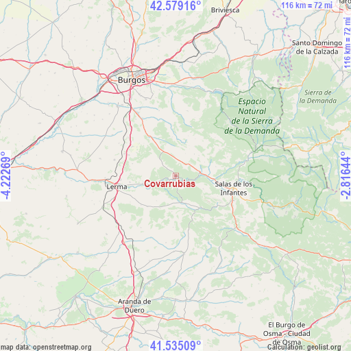
42° 3' 33.372" North, 3° 31' 10.416" West
| Map corner | latitude | longitude |
|---|---|---|
| Upper-left | 42.57916°, | -4.22269° |
| Center: | 42.05927°, | -3.51956° |
| Lower-right: | 41.53509°, | -2.81644° |
| Map W x H: | 116.1×116.1 km | = 72.1×72.1mi |
| max Lat: | 43.74134° ⇑24.6% North |
| Covarrubias: | 42.05927° |
| min Lat: | ⇓75.4% South 27.64134° |
| min Long | Covarrubias | max Long |
| -18.00367° | -3.51956° | 4.2899° |
| W 47.5%⇐ | ⇒52.5% E |
Elevation
Elevation of Covarrubias is 892 m = 2927 ft, and this is 294 m = 965 ft above average elevation for this country.
| Max E: |
1682 m = 5518 ft | 20.6% |
| Covarrubias | 892 m 2927 ft | |
| Avg. | 598 m = 1962 ft | |
Min E: |
0 m = 0 ft | 79.4% |
See also: Spain elevation on elevation.city.
Geographical zone
Covarrubias is located in North temperate zone (between Tropic of Cancer and the Arctic Circle). Distance of this Northern Tropic circle is 2070.6 km =1286.6 mi to South.| Distance of | km | miles | from Covarrubias |
|---|---|---|---|
| North Pole | 5330.5 | 3312.2 | to North |
| Arctic Circle | 2724.6 | 1693 | to North |
| Tropic Cancer | 2070.6 | 1286.6 | to South |
| Equator | 4676.6 | 2905.9 | to South |


Nearby cities:
15 places around Covarrubias: (largest is in red/bold)
• Campolara
10.1 km =6.3 mi,  48°
48°
• Cascajares de la Sierra
9.9 km =6.2 mi,  88°
88°
• Cebrecos
10.5 km =6.5 mi,  217°
217°
• Contreras
10 km =6.2 mi,  115°
115°
• Cuevas de San Clemente
8.8 km =5.5 mi,  332°
332°
• Hortigüela
7.8 km =4.8 mi,  82°
82°
• Mambrillas de Lara
6.2 km =3.9 mi, 50°
• Mecerreyes
6 km =3.7 mi,  311°
311°
• Puentedura
5.5 km =3.4 mi,  248°
248°
• Quintanilla del Coco
8.4 km =5.2 mi,  178°
178°
• Retuerta
3.5 km =2.2 mi,  162°
162°
• Santibáñez del Val
10 km =6.2 mi, 161°
• Tejada
11.9 km =7.4 mi,  186°
186°
• Torrelara
12 km =7.5 mi,  1°
1°
• Villaespasa
10.5 km =6.5 mi,  64°
64°
Sources, notices
• [Note1] Compared only with cities in Spain existing in our database
• [Src1] Map data: © OpenStreetMap contributors (CC-BY-SA)
• [Src2] Other city data from geonames.org with taken over terms of usage.
• [Src3] Geographical zone / Annual Mean Temperature by Robert A. Rohde @ Wikipedia
