Hernán-Pérez geodata
Hernán-Pérez (Extremadura) is a seat of a third-order administrative division; located in Spain in Europe/Madrid (GMT+2) time zone. With population of 503 people, there are 3875 cities with bigger population in this country. Compared to other cities in Spain, 67% of cities are located further ↑North; 90.9% of cities are located further →East and 66.3% of cities have higher elevation than Hernán-Pérez. Note1
Administrative division(s):
- Level 1: Extremadura
- Level 2: Provincia de Cáceres
- Level 3: Hernán-Pérez


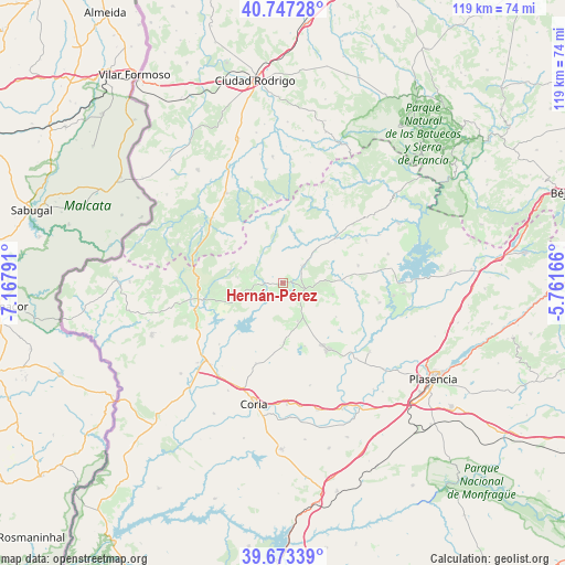
Hernán-Pérez GPS coordinates[2]
40° 12' 44.856" North, 6° 27' 53.244" West
| Map corner | latitude | longitude |
|---|---|---|
| Upper-left | 40.74728°, | -7.16791° |
| Center: | 40.21246°, | -6.46479° |
| Lower-right: | 39.67339°, | -5.76166° |
| Map W x H: | 119.4×119.4 km | = 74.2×74.2mi |
| max Lat: | 43.74134° ⇑67% North |
| Hernán-Pérez: | 40.21246° |
| min Lat: | ⇓33% South 27.64134° |
| min Long | Hernán-Pérez | max Long |
| -18.00367° | -6.46479° | 4.2899° |
| W 9.1%⇐ | ⇒90.9% E |
Elevation
Elevation of Hernán-Pérez is 442 m = 1450 ft, and this is 156 m = 512 ft below average elevation for this country.
| Max E: |
1682 m = 5518 ft | 66.3% |
| Avg. | 598 m = 1962 ft | |
| Hernán-Pérez | 442 m = 1450 ft | |
Min E: |
0 m = 0 ft | 33.7% |
See also: Spain elevation on elevation.city.
Geographical zone
Hernán-Pérez is located in North temperate zone (between Tropic of Cancer and the Arctic Circle). Distance of this Northern Tropic circle is 1865.3 km =1159 mi to South.| Distance of | km | miles | from Hernán-Pérez |
|---|---|---|---|
| North Pole | 5535.9 | 3439.8 | to North |
| Arctic Circle | 2930 | 1820.6 | to North |
| Tropic Cancer | 1865.3 | 1159 | to South |
| Equator | 4471.2 | 2778.3 | to South |


Nearby cities:
15 places around Hernán-Pérez: (largest is in red/bold)
• Aceituna
13.2 km =8.2 mi,  121°
121°
• Cadalso
7 km =4.3 mi,  293°
293°
• Descargamaría
10.4 km =6.5 mi,  349°
349°
• Gata
11.6 km =7.2 mi,  283°
283°
• Guijo de Coria
12.4 km =7.7 mi,  179°
179°
• Guijo de Galisteo
14 km =8.7 mi,  160°
160°
• Pozuelo de Zarzón
8.3 km =5.2 mi,  149°
149°
• Robledillo de Gata
12.2 km =7.6 mi,  357°
357°
• Santa Cruz de Paniagua
10.8 km =6.7 mi,  102°
102°
• Santibáñez el Alto
7.7 km =4.8 mi,  246°
246°
• Torre de Don Miguel
9.6 km =6 mi, 277°
• Torrecilla de los Ángeles
5.7 km =3.5 mi,  46°
46°
• Villa del Campo
8.4 km =5.2 mi, 157°
• Villanueva de la Sierra
5.1 km =3.2 mi, 103°
• Villasbuenas de Gata
14.2 km =8.8 mi, 254°
Sources, notices
• [Note1] Compared only with cities in Spain existing in our database
• [Src1] Map data: © OpenStreetMap contributors (CC-BY-SA)
• [Src2] Other city data from geonames.org with taken over terms of usage.
• [Src3] Geographical zone / Annual Mean Temperature by Robert A. Rohde @ Wikipedia
