Gata geodata
Gata (Extremadura) is a seat of a third-order administrative division; located in Spain in Europe/Madrid (GMT+2) time zone. With population of 1,788 people, there are 2295 cities with bigger population in this country. Compared to other cities in Spain, 66.6% of cities are located further ↑North; 91.9% of cities are located further →East and 51.6% of cities have higher elevation than Gata. Note1


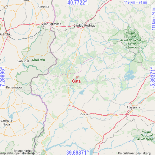
Gata GPS coordinates[2]
40° 14' 15.288" North, 6° 35' 48.624" West
| Map corner | latitude | longitude |
|---|---|---|
| Upper-left | 40.7722°, | -7.29996° |
| Center: | 40.23758°, | -6.59684° |
| Lower-right: | 39.69871°, | -5.89371° |
| Map W x H: | 119.4×119.4 km | = 74.2×74.2mi |
| max Lat: | 43.74134° ⇑66.6% North |
| Gata: | 40.23758° |
| min Lat: | ⇓33.4% South 27.64134° |
| min Long | Gata | max Long |
| -18.00367° | -6.59684° | 4.2899° |
| W 8.1%⇐ | ⇒91.9% E |
Elevation
Elevation of Gata is 642 m = 2106 ft, and this is 44 m = 144 ft above average elevation for this country.
| Max E: |
1682 m = 5518 ft | 51.6% |
| Gata | 642 m 2106 ft | |
| Avg. | 598 m = 1962 ft | |
Min E: |
0 m = 0 ft | 48.4% |
See also: Spain elevation on elevation.city.
Geographical zone
Gata is located in North temperate zone (between Tropic of Cancer and the Arctic Circle). Distance of this Northern Tropic circle is 1868.1 km =1160.8 mi to South.| Distance of | km | miles | from Gata |
|---|---|---|---|
| North Pole | 5533.1 | 3438.1 | to North |
| Arctic Circle | 2927.2 | 1818.9 | to North |
| Tropic Cancer | 1868.1 | 1160.8 | to South |
| Equator | 4474 | 2780 | to South |


Nearby cities:
15 places around Gata: (largest is in red/bold)
• Acebo
11 km =6.8 mi,  248°
248°
• Cadalso
4.8 km =3 mi,  90°
90°
• Descargamaría
11.9 km =7.4 mi,  51°
51°
• Hernán-Pérez
11.6 km =7.2 mi,  103°
103°
• Hoyos
12.8 km =8 mi,  235°
235°
• Perales del Puerto
11.6 km =7.2 mi,  218°
218°
• Peñaparda
11.1 km =6.9 mi,  326°
326°
• Robleda
16.4 km =10.2 mi,  356°
356°
• Robledillo de Gata
14.2 km =8.8 mi, 48°
• Santibáñez el Alto
7.2 km =4.5 mi,  144°
144°
• Torre de Don Miguel
2.3 km =1.4 mi,  133°
133°
• Torrecilla de los Ángeles
15.4 km =9.6 mi, 85°
• Villanueva de la Sierra
16.7 km =10.4 mi, 103°
• Villasbuenas de Gata
7 km =4.3 mi,  201°
201°
• Villasrubias
11.8 km =7.3 mi,  342°
342°
Sources, notices
• [Note1] Compared only with cities in Spain existing in our database
• [Src1] Map data: © OpenStreetMap contributors (CC-BY-SA)
• [Src2] Other city data from geonames.org with taken over terms of usage.
• [Src3] Geographical zone / Annual Mean Temperature by Robert A. Rohde @ Wikipedia
