Robledillo de Gata geodata
Robledillo de Gata (Extremadura) is a seat of a third-order administrative division; located in Spain in Europe/Madrid (GMT+2) time zone. With population of 150 people, there are 5428 cities with bigger population in this country. Compared to other cities in Spain, 65.4% of cities are located further ↑North; 91% of cities are located further →East and 56.4% of cities have higher elevation than Robledillo de Gata. Note1
Administrative division(s):
- Level 1: Extremadura
- Level 2: Provincia de Cáceres
- Level 3: Robledillo de Gata


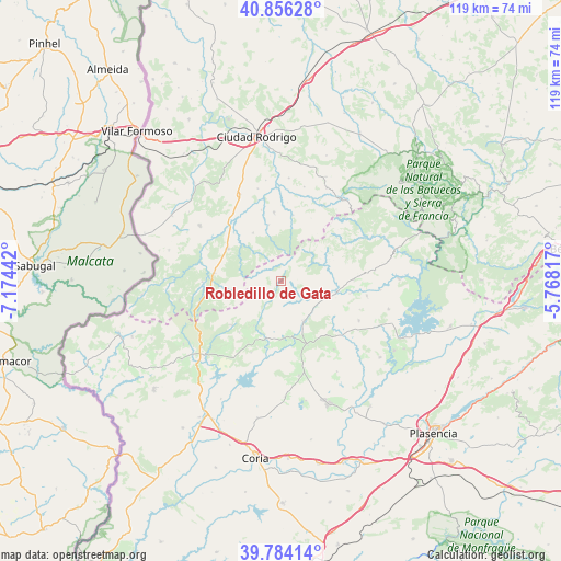
Robledillo de Gata GPS coordinates[2]
40° 19' 20.424" North, 6° 28' 16.644" West
| Map corner | latitude | longitude |
|---|---|---|
| Upper-left | 40.85628°, | -7.17442° |
| Center: | 40.32234°, | -6.47129° |
| Lower-right: | 39.78414°, | -5.76817° |
| Map W x H: | 119.2×119.2 km | = 74.1×74.1mi |
| max Lat: | 43.74134° ⇑65.4% North |
| Robledillo de Gata: | 40.32234° |
| min Lat: | ⇓34.6% South 27.64134° |
| min Long | Robledillo de G | max Long |
| -18.00367° | -6.47129° | 4.2899° |
| W 9%⇐ | ⇒91% E |
Elevation
Elevation of Robledillo de Gata is 575 m = 1886 ft, and this is 23 m = 75 ft below average elevation for this country.
| Max E: |
1682 m = 5518 ft | 56.4% |
| Avg. | 598 m = 1962 ft | |
| Robledillo de Gata | 575 m = 1886 ft | |
Min E: |
0 m = 0 ft | 43.6% |
See also: Spain elevation on elevation.city.
Geographical zone
Robledillo de Gata is located in North temperate zone (between Tropic of Cancer and the Arctic Circle). Distance of this Northern Tropic circle is 1877.5 km =1166.6 mi to South.| Distance of | km | miles | from Robledillo de Gata |
|---|---|---|---|
| North Pole | 5523.6 | 3432.2 | to North |
| Arctic Circle | 2917.8 | 1813 | to North |
| Tropic Cancer | 1877.5 | 1166.6 | to South |
| Equator | 4483.4 | 2785.9 | to South |


Nearby cities:
15 places around Robledillo de Gata: (largest is in red/bold)
• Agallas
14.3 km =8.9 mi,  10°
10°
• Cadalso
11.1 km =6.9 mi,  211°
211°
• Caminomorisco
15.4 km =9.6 mi,  87°
87°
• Descargamaría
2.4 km =1.5 mi, 213°
• Gata
14.2 km =8.8 mi,  228°
228°
• Herguijuela de Ciudad Rodrigo
15.7 km =9.8 mi,  344°
344°
• Hernán-Pérez
12.2 km =7.6 mi,  177°
177°
• Martiago
14.7 km =9.1 mi,  353°
353°
• Pinofranqueado
12 km =7.5 mi,  100°
100°
• Robleda
13.4 km =8.3 mi,  301°
301°
• Santibáñez el Alto
16.6 km =10.3 mi,  203°
203°
• Torre de Don Miguel
14.2 km =8.8 mi,  219°
219°
• Torrecilla de los Ángeles
9.5 km =5.9 mi,  150°
150°
• Villanueva de la Sierra
14.5 km =9 mi,  157°
157°
• Villasrubias
14.3 km =8.9 mi,  277°
277°
Sources, notices
• [Note1] Compared only with cities in Spain existing in our database
• [Src1] Map data: © OpenStreetMap contributors (CC-BY-SA)
• [Src2] Other city data from geonames.org with taken over terms of usage.
• [Src3] Geographical zone / Annual Mean Temperature by Robert A. Rohde @ Wikipedia
