Descargamaría geodata
Descargamaría (Extremadura) is a seat of a third-order administrative division; located in Spain in Europe/Madrid (GMT+2) time zone. With population of 285 people, there are 4564 cities with bigger population in this country. Compared to other cities in Spain, 65.7% of cities are located further ↑North; 91.1% of cities are located further →East and 61.4% of cities have higher elevation than Descargamaría. Note1
Administrative division(s):
- Level 1: Extremadura
- Level 2: Provincia de Cáceres
- Level 3: Descargamaría


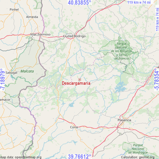
Descargamaría GPS coordinates[2]
40° 18' 16.056" North, 6° 29' 11.976" West
| Map corner | latitude | longitude |
|---|---|---|
| Upper-left | 40.83855°, | -7.18979° |
| Center: | 40.30446°, | -6.48666° |
| Lower-right: | 39.76612°, | -5.78354° |
| Map W x H: | 119.2×119.2 km | = 74.1×74.1mi |
| max Lat: | 43.74134° ⇑65.7% North |
| Descargamaría: | 40.30446° |
| min Lat: | ⇓34.3% South 27.64134° |
| min Long | Descargamaría | max Long |
| -18.00367° | -6.48666° | 4.2899° |
| W 8.9%⇐ | ⇒91.1% E |
Elevation
Elevation of Descargamaría is 506 m = 1660 ft, and this is 92 m = 302 ft below average elevation for this country.
| Max E: |
1682 m = 5518 ft | 61.4% |
| Avg. | 598 m = 1962 ft | |
| Descargamaría | 506 m = 1660 ft | |
Min E: |
0 m = 0 ft | 38.6% |
See also: Spain elevation on elevation.city.
Geographical zone
Descargamaría is located in North temperate zone (between Tropic of Cancer and the Arctic Circle). Distance of this Northern Tropic circle is 1875.5 km =1165.4 mi to South.| Distance of | km | miles | from Descargamaría |
|---|---|---|---|
| North Pole | 5525.6 | 3433.4 | to North |
| Arctic Circle | 2919.7 | 1814.2 | to North |
| Tropic Cancer | 1875.5 | 1165.4 | to South |
| Equator | 4481.4 | 2784.6 | to South |


Nearby cities:
15 places around Descargamaría: (largest is in red/bold)
• Agallas
16.5 km =10.3 mi,  13°
13°
• Cadalso
8.8 km =5.5 mi,  211°
211°
• Caminomorisco
16.9 km =10.5 mi,  81°
81°
• Gata
11.9 km =7.4 mi,  231°
231°
• Hernán-Pérez
10.4 km =6.5 mi,  169°
169°
• Martiago
16.7 km =10.4 mi,  358°
358°
• Peñaparda
15.6 km =9.7 mi,  276°
276°
• Pinofranqueado
13.1 km =8.1 mi,  90°
90°
• Robleda
13.6 km =8.5 mi,  311°
311°
• Robledillo de Gata
2.4 km =1.5 mi,  33°
33°
• Santibáñez el Alto
14.2 km =8.8 mi,  201°
201°
• Torre de Don Miguel
11.8 km =7.3 mi,  220°
220°
• Torrecilla de los Ángeles
8.7 km =5.4 mi,  136°
136°
• Villanueva de la Sierra
13.3 km =8.3 mi,  149°
149°
• Villasrubias
13.5 km =8.4 mi,  286°
286°
Sources, notices
• [Note1] Compared only with cities in Spain existing in our database
• [Src1] Map data: © OpenStreetMap contributors (CC-BY-SA)
• [Src2] Other city data from geonames.org with taken over terms of usage.
• [Src3] Geographical zone / Annual Mean Temperature by Robert A. Rohde @ Wikipedia
