Henche geodata
Henche (Castille-La Mancha) is a seat of a third-order administrative division; located in Spain in Europe/Madrid (GMT+2) time zone. With population of 119 people, there are 5710 cities with bigger population in this country. Compared to other cities in Spain, 57.8% of cities are located further ↑North; 58.5% of cities are located further ←West and 72% of cities have lower elevation than Henche. Note1
Administrative division(s):
- Level 1: Castille-La Mancha
- Level 2: Provincia de Guadalajara
- Level 3: Henche


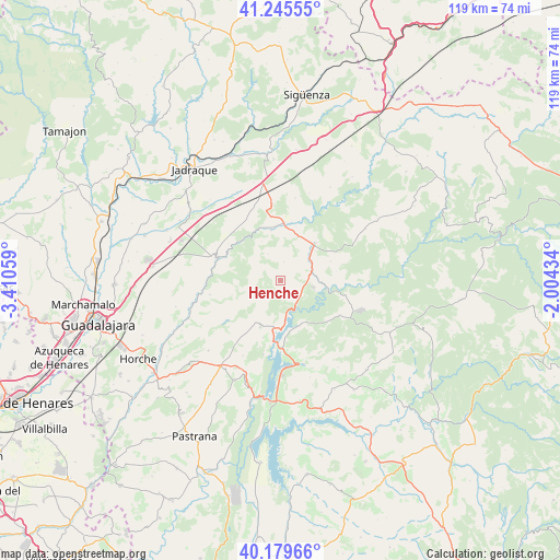
Henche GPS coordinates[2]
40° 42' 53.064" North, 2° 42' 26.856" West
| Map corner | latitude | longitude |
|---|---|---|
| Upper-left | 41.24555°, | -3.41059° |
| Center: | 40.71474°, | -2.70746° |
| Lower-right: | 40.17966°, | -2.00434° |
| Map W x H: | 118.5×118.5 km | = 73.6×73.6mi |
| max Lat: | 43.74134° ⇑57.8% North |
| Henche: | 40.71474° |
| min Lat: | ⇓42.2% South 27.64134° |
| min Long | Henche | max Long |
| -18.00367° | -2.70746° | 4.2899° |
| W 58.5%⇐ | ⇒41.5% E |
Elevation
Elevation of Henche is 827 m = 2713 ft, and this is 229 m = 751 ft above average elevation for this country.
| Max E: |
1682 m = 5518 ft | 28% |
| Henche | 827 m 2713 ft | |
| Avg. | 598 m = 1962 ft | |
Min E: |
0 m = 0 ft | 72% |
See also: Spain elevation on elevation.city.
Geographical zone
Henche is located in North temperate zone (between Tropic of Cancer and the Arctic Circle). Distance of this Northern Tropic circle is 1921.1 km =1193.7 mi to South.| Distance of | km | miles | from Henche |
|---|---|---|---|
| North Pole | 5480 | 3405.1 | to North |
| Arctic Circle | 2874.1 | 1785.9 | to North |
| Tropic Cancer | 1921.1 | 1193.7 | to South |
| Equator | 4527.1 | 2813 | to South |


Nearby cities:
15 places around Henche: (largest is in red/bold)
• Alique
15.2 km =9.4 mi,  159°
159°
• Barriopedro
9.2 km =5.7 mi,  335°
335°
• Brihuega
14.6 km =9.1 mi,  290°
290°
• Budia
10.6 km =6.6 mi,  203°
203°
• Chillarón del Rey
13 km =8.1 mi,  173°
173°
• Cifuentes
10.7 km =6.6 mi,  42°
42°
• Cogollor
15.2 km =9.4 mi,  348°
348°
• Durón
10.1 km =6.3 mi,  189°
189°
• Mantiel
11.3 km =7 mi, 160°
• Masegoso de Tajuña
12.4 km =7.7 mi,  4°
4°
• San Andrés del Rey
12.7 km =7.9 mi,  228°
228°
• Solanillos del Extremo
4.1 km =2.5 mi,  11°
11°
• Trillo
9.8 km =6.1 mi,  99°
99°
• Valderrebollo
10.8 km =6.7 mi, 350°
• Yélamos de Arriba
14.2 km =8.8 mi, 234°
Sources, notices
• [Note1] Compared only with cities in Spain existing in our database
• [Src1] Map data: © OpenStreetMap contributors (CC-BY-SA)
• [Src2] Other city data from geonames.org with taken over terms of usage.
• [Src3] Geographical zone / Annual Mean Temperature by Robert A. Rohde @ Wikipedia
