Brihuega geodata
Brihuega (Castille-La Mancha) is a seat of a third-order administrative division; located in Spain in Europe/Madrid (GMT+2) time zone. With population of 2,776 people, there are 1789 cities with bigger population in this country. Compared to other cities in Spain, 57% of cities are located further ↑North; 56.4% of cities are located further ←West and 82.1% of cities have lower elevation than Brihuega. Note1
Administrative division(s):
- Level 1: Castille-La Mancha
- Level 2: Provincia de Guadalajara
- Level 3: Brihuega


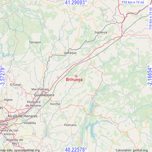
Brihuega GPS coordinates[2]
40° 45' 37.764" North, 2° 52' 10.776" West
| Map corner | latitude | longitude |
|---|---|---|
| Upper-left | 41.29093°, | -3.57279° |
| Center: | 40.76049°, | -2.86966° |
| Lower-right: | 40.22578°, | -2.16654° |
| Map W x H: | 118.4×118.4 km | = 73.6×73.6mi |
| max Lat: | 43.74134° ⇑57% North |
| Brihuega: | 40.76049° |
| min Lat: | ⇓43% South 27.64134° |
| min Long | Brihuega | max Long |
| -18.00367° | -2.86966° | 4.2899° |
| W 56.4%⇐ | ⇒43.6% E |
Elevation
Elevation of Brihuega is 918 m = 3012 ft, and this is 320 m = 1050 ft above average elevation for this country.
| Max E: |
1682 m = 5518 ft | 17.9% |
| Brihuega | 918 m 3012 ft | |
| Avg. | 598 m = 1962 ft | |
Min E: |
0 m = 0 ft | 82.1% |
See also: Spain elevation on elevation.city.
Geographical zone
Brihuega is located in North temperate zone (between Tropic of Cancer and the Arctic Circle). Distance of this Northern Tropic circle is 1926.2 km =1196.9 mi to South.| Distance of | km | miles | from Brihuega |
|---|---|---|---|
| North Pole | 5474.9 | 3401.9 | to North |
| Arctic Circle | 2869 | 1782.7 | to North |
| Tropic Cancer | 1926.2 | 1196.9 | to South |
| Equator | 4532.1 | 2816.1 | to South |


Nearby cities:
15 places around Brihuega: (largest is in red/bold)
• Argecilla
14 km =8.7 mi,  16°
16°
• Barriopedro
10.4 km =6.5 mi,  71°
71°
• Caspueñas
11.8 km =7.3 mi,  231°
231°
• Gajanejos
9.2 km =5.7 mi,  348°
348°
• Ledanca
12.2 km =7.6 mi,  10°
10°
• Muduex
10.7 km =6.6 mi,  315°
315°
• San Andrés del Rey
14.2 km =8.8 mi,  162°
162°
• Torija
13.5 km =8.4 mi,  261°
261°
• Trijueque
10.5 km =6.5 mi,  278°
278°
• Utande
10.9 km =6.8 mi,  333°
333°
• Valdearenas
11.7 km =7.3 mi,  297°
297°
• Valdeavellano
13.5 km =8.4 mi,  218°
218°
• Valdegrudas
13.2 km =8.2 mi,  245°
245°
• Valderrebollo
13.1 km =8.1 mi,  64°
64°
• Yélamos de Arriba
13.6 km =8.5 mi,  170°
170°
Sources, notices
• [Note1] Compared only with cities in Spain existing in our database
• [Src1] Map data: © OpenStreetMap contributors (CC-BY-SA)
• [Src2] Other city data from geonames.org with taken over terms of usage.
• [Src3] Geographical zone / Annual Mean Temperature by Robert A. Rohde @ Wikipedia
