Barriopedro geodata
Barriopedro (Castille-La Mancha) is a seat of a third-order administrative division; located in Spain in Europe/Madrid (GMT+2) time zone. With population of 33 people, there are 6634 cities with bigger population in this country. Compared to other cities in Spain, 56.4% of cities are located further ↑North; 58.1% of cities are located further ←West and 79.9% of cities have lower elevation than Barriopedro. Note1
Administrative division(s):
- Level 1: Castille-La Mancha
- Level 2: Provincia de Guadalajara
- Level 3: Barriopedro


Barriopedro GPS coordinates[2]
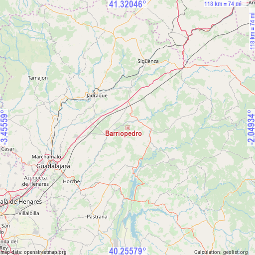
40° 47' 24.936" North, 2° 45' 8.856" West
| Map corner | latitude | longitude |
|---|---|---|
| Upper-left | 41.32046°, | -3.45559° |
| Center: | 40.79026°, | -2.75246° |
| Lower-right: | 40.25579°, | -2.04934° |
| Map W x H: | 118.4×118.4 km | = 73.6×73.6mi |
| max Lat: | 43.74134° ⇑56.4% North |
| Barriopedro: | 40.79026° |
| min Lat: | ⇓43.6% South 27.64134° |
| min Long | Barriopedro | max Long |
| -18.00367° | -2.75246° | 4.2899° |
| W 58.1%⇐ | ⇒41.9% E |
Elevation
Elevation of Barriopedro is 896 m = 2940 ft, and this is 298 m = 978 ft above average elevation for this country.
| Max E: |
1682 m = 5518 ft | 20.1% |
| Barriopedro | 896 m 2940 ft | |
| Avg. | 598 m = 1962 ft | |
Min E: |
0 m = 0 ft | 79.9% |
See also: Spain elevation on elevation.city.
Geographical zone
Barriopedro is located in North temperate zone (between Tropic of Cancer and the Arctic Circle). Distance of this Northern Tropic circle is 1929.5 km =1198.9 mi to South.| Distance of | km | miles | from Barriopedro |
|---|---|---|---|
| North Pole | 5471.6 | 3399.9 | to North |
| Arctic Circle | 2865.7 | 1780.7 | to North |
| Tropic Cancer | 1929.5 | 1198.9 | to South |
| Equator | 4535.5 | 2818.2 | to South |


Nearby cities:
15 places around Barriopedro: (largest is in red/bold)
• Alaminos
8.4 km =5.2 mi,  15°
15°
• Almadrones
12.4 km =7.7 mi,  351°
351°
• Argecilla
11.7 km =7.3 mi,  330°
330°
• Brihuega
10.4 km =6.5 mi,  251°
251°
• Castejón de Henares
16.6 km =10.3 mi, 350°
• Cifuentes
11 km =6.8 mi,  92°
92°
• Cogollor
6.5 km =4 mi,  6°
6°
• Gajanejos
13.1 km =8.1 mi,  295°
295°
• Henche
9.2 km =5.7 mi,  155°
155°
• Ledanca
11.6 km =7.2 mi,  318°
318°
• Masegoso de Tajuña
6.2 km =3.9 mi,  50°
50°
• Solanillos del Extremo
6.3 km =3.9 mi,  133°
133°
• Trillo
16.7 km =10.4 mi, 126°
• Utande
16.1 km =10 mi,  293°
293°
• Valderrebollo
3 km =1.9 mi,  41°
41°
Sources, notices
• [Note1] Compared only with cities in Spain existing in our database
• [Src1] Map data: © OpenStreetMap contributors (CC-BY-SA)
• [Src2] Other city data from geonames.org with taken over terms of usage.
• [Src3] Geographical zone / Annual Mean Temperature by Robert A. Rohde @ Wikipedia
