Guijuelo geodata
Guijuelo (Castille and León) is a seat of a third-order administrative division; located in Spain in Europe/Madrid (GMT+2) time zone. With population of 5,221 people, there are 1262 cities with bigger population in this country. Compared to other cities in Spain, 60.6% of cities are located further ↑North; 81.3% of cities are located further →East and 88.7% of cities have lower elevation than Guijuelo. Note1
Administrative division(s):
- Level 1: Castille and León
- Level 2: Provincia de Salamanca
- Level 3: Guijuelo


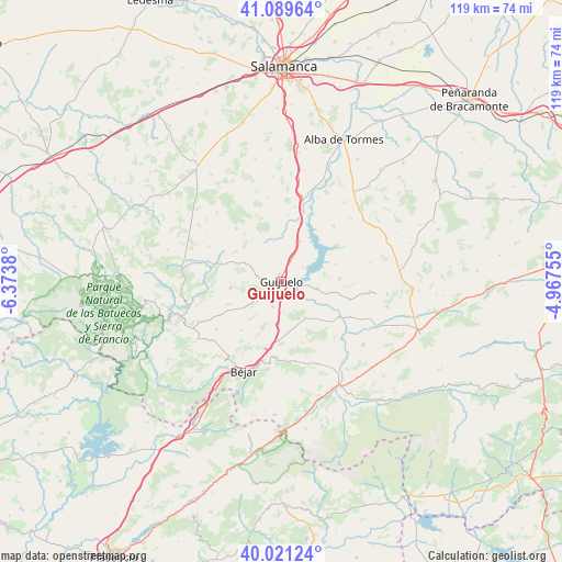
Guijuelo GPS coordinates[2]
40° 33' 27.252" North, 5° 40' 14.412" West
| Map corner | latitude | longitude |
|---|---|---|
| Upper-left | 41.08964°, | -6.3738° |
| Center: | 40.55757°, | -5.67067° |
| Lower-right: | 40.02124°, | -4.96755° |
| Map W x H: | 118.8×118.8 km | = 73.8×73.8mi |
| max Lat: | 43.74134° ⇑60.6% North |
| Guijuelo: | 40.55757° |
| min Lat: | ⇓39.4% South 27.64134° |
| min Long | Guijuelo | max Long |
| -18.00367° | -5.67067° | 4.2899° |
| W 18.7%⇐ | ⇒81.3% E |
Elevation
Elevation of Guijuelo is 1009 m = 3310 ft, and this is 411 m = 1348 ft above average elevation for this country.
| Max E: |
1682 m = 5518 ft | 11.3% |
| Guijuelo | 1009 m 3310 ft | |
| Avg. | 598 m = 1962 ft | |
Min E: |
0 m = 0 ft | 88.7% |
See also: Spain elevation on elevation.city.
Geographical zone
Guijuelo is located in North temperate zone (between Tropic of Cancer and the Arctic Circle). Distance of this Northern Tropic circle is 1903.7 km =1182.9 mi to South.| Distance of | km | miles | from Guijuelo |
|---|---|---|---|
| North Pole | 5497.5 | 3416 | to North |
| Arctic Circle | 2891.6 | 1796.8 | to North |
| Tropic Cancer | 1903.7 | 1182.9 | to South |
| Equator | 4509.6 | 2802.1 | to South |


Nearby cities:
15 places around Guijuelo: (largest is in red/bold)
• Aldeavieja de Tormes
5.3 km =3.3 mi,  57°
57°
• Berrocal de Salvatierra
8.6 km =5.3 mi,  349°
349°
• Casafranca
8.5 km =5.3 mi,  297°
297°
• Cespedosa
7.8 km =4.8 mi,  101°
101°
• Fuenterroble de Salvatierra
5.4 km =3.4 mi,  278°
278°
• Fuentes de Béjar
5.8 km =3.6 mi,  198°
198°
• Guijo de Ávila
4 km =2.5 mi,  138°
138°
• Ledrada
10.7 km =6.6 mi, 203°
• Montejo
9.3 km =5.8 mi,  25°
25°
• Nava de Béjar
9.2 km =5.7 mi,  184°
184°
• Pizarral
6.5 km =4 mi,  13°
13°
• Puebla de San Medel
7.6 km =4.7 mi,  226°
226°
• Salvatierra de Tormes
7.1 km =4.4 mi, 59°
• Santibáñez de Béjar
9.2 km =5.7 mi,  146°
146°
• Valdelacasa
9.7 km =6 mi, 234°
Sources, notices
• [Note1] Compared only with cities in Spain existing in our database
• [Src1] Map data: © OpenStreetMap contributors (CC-BY-SA)
• [Src2] Other city data from geonames.org with taken over terms of usage.
• [Src3] Geographical zone / Annual Mean Temperature by Robert A. Rohde @ Wikipedia
