Santibáñez de Béjar geodata
Santibáñez de Béjar (Castille and León) is a seat of a third-order administrative division; located in Spain in Europe/Madrid (GMT+2) time zone. With population of 606 people, there are 3601 cities with bigger population in this country. Compared to other cities in Spain, 62.1% of cities are located further ↑North; 80.3% of cities are located further →East and 82.3% of cities have lower elevation than Santibáñez de Béjar. Note1
Administrative division(s):
- Level 1: Castille and León
- Level 2: Provincia de Salamanca
- Level 3: Santibáñez de Béjar


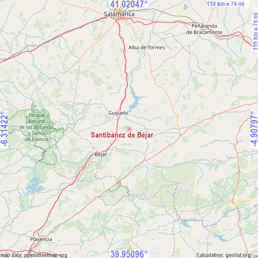
Santibáñez de Béjar GPS coordinates[2]
40° 29' 16.26" North, 5° 36' 39.96" West
| Map corner | latitude | longitude |
|---|---|---|
| Upper-left | 41.02047°, | -6.31422° |
| Center: | 40.48785°, | -5.6111° |
| Lower-right: | 39.95096°, | -4.90797° |
| Map W x H: | 118.9×118.9 km | = 73.9×73.9mi |
| max Lat: | 43.74134° ⇑62.1% North |
| Santibáñez de Béjar: | 40.48785° |
| min Lat: | ⇓37.9% South 27.64134° |
| min Long | Santibáñez de | max Long |
| -18.00367° | -5.6111° | 4.2899° |
| W 19.7%⇐ | ⇒80.3% E |
Elevation
Elevation of Santibáñez de Béjar is 920 m = 3018 ft, and this is 322 m = 1056 ft above average elevation for this country.
| Max E: |
1682 m = 5518 ft | 17.7% |
| Santibáñez de Béjar | 920 m 3018 ft | |
| Avg. | 598 m = 1962 ft | |
Min E: |
0 m = 0 ft | 82.3% |
See also: Spain elevation on elevation.city.
Geographical zone
Santibáñez de Béjar is located in North temperate zone (between Tropic of Cancer and the Arctic Circle). Distance of this Northern Tropic circle is 1895.9 km =1178.1 mi to South.| Distance of | km | miles | from Santibáñez de Béjar |
|---|---|---|---|
| North Pole | 5505.2 | 3420.8 | to North |
| Arctic Circle | 2899.3 | 1801.5 | to North |
| Tropic Cancer | 1895.9 | 1178.1 | to South |
| Equator | 4501.8 | 2797.3 | to South |


Nearby cities:
15 places around Santibáñez de Béjar: (largest is in red/bold)
• Aldeavieja de Tormes
10.6 km =6.6 mi,  357°
357°
• Becedas
9.6 km =6 mi,  192°
192°
• Cespedosa
6.7 km =4.2 mi,  22°
22°
• Fresnedoso
10.1 km =6.3 mi,  235°
235°
• Fuentes de Béjar
7.3 km =4.5 mi,  288°
288°
• Guijo de Ávila
5.4 km =3.4 mi,  333°
333°
• Guijuelo
9.2 km =5.7 mi, 326°
• Junciana
9.7 km =6 mi,  151°
151°
• Ledrada
9.5 km =5.9 mi,  257°
257°
• Medinilla
5.4 km =3.4 mi, 185°
• Nava de Béjar
5.9 km =3.7 mi, 256°
• Neila de San Miguel
7.9 km =4.9 mi,  205°
205°
• Puente del Congosto
7.2 km =4.5 mi,  87°
87°
• San Bartolomé de Béjar
9.9 km =6.2 mi, 206°
• Sorihuela
7.5 km =4.7 mi,  229°
229°
Sources, notices
• [Note1] Compared only with cities in Spain existing in our database
• [Src1] Map data: © OpenStreetMap contributors (CC-BY-SA)
• [Src2] Other city data from geonames.org with taken over terms of usage.
• [Src3] Geographical zone / Annual Mean Temperature by Robert A. Rohde @ Wikipedia
