Bascuñana geodata
Bascuñana (Castille and León) is a seat of a third-order administrative division; located in Spain in Europe/Madrid (GMT+2) time zone. With population of 61 people, there are 6339 cities with bigger population in this country. Compared to other cities in Spain, 85.6% of cities are located further ↓South; 53.1% of cities are located further ←West and 68.1% of cities have lower elevation than Bascuñana. Note1
Administrative division(s):
- Level 1: Castille and León
- Level 2: Provincia de Burgos
- Level 3: Bascuñana


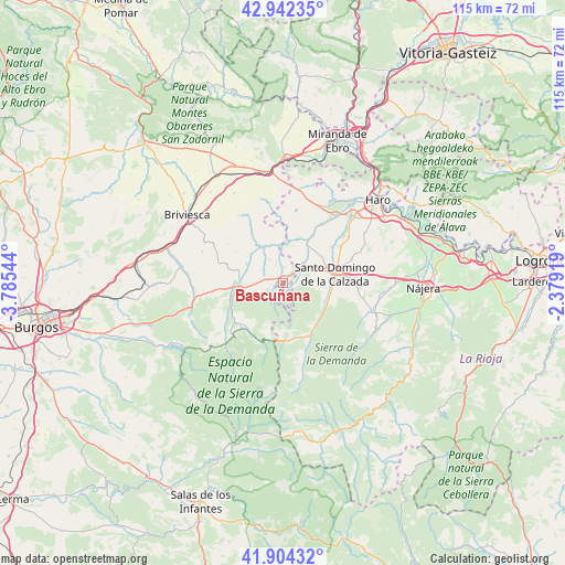
Bascuñana GPS coordinates[2]
42° 25' 31.728" North, 3° 4' 56.316" West
| Map corner | latitude | longitude |
|---|---|---|
| Upper-left | 42.94235°, | -3.78544° |
| Center: | 42.42548°, | -3.08231° |
| Lower-right: | 41.90432°, | -2.37919° |
| Map W x H: | 115.4×115.4 km | = 71.7×71.7mi |
| max Lat: | 43.74134° ⇑14.4% North |
| Bascuñana: | 42.42548° |
| min Lat: | ⇓85.6% South 27.64134° |
| min Long | Bascuñana | max Long |
| -18.00367° | -3.08231° | 4.2899° |
| W 53.1%⇐ | ⇒46.9% E |
Elevation
Elevation of Bascuñana is 800 m = 2625 ft, and this is 202 m = 663 ft above average elevation for this country.
| Max E: |
1682 m = 5518 ft | 31.9% |
| Bascuñana | 800 m 2625 ft | |
| Avg. | 598 m = 1962 ft | |
Min E: |
0 m = 0 ft | 68.1% |
See also: Spain elevation on elevation.city.
Geographical zone
Bascuñana is located in North temperate zone (between Tropic of Cancer and the Arctic Circle). Distance of this Northern Tropic circle is 2111.4 km =1312 mi to South.| Distance of | km | miles | from Bascuñana |
|---|---|---|---|
| North Pole | 5289.8 | 3286.9 | to North |
| Arctic Circle | 2683.9 | 1667.7 | to North |
| Tropic Cancer | 2111.4 | 1312 | to South |
| Equator | 4717.3 | 2931.2 | to South |


Nearby cities:
15 places around Bascuñana: (largest is in red/bold)
• Belorado
9 km =5.6 mi,  266°
266°
• Castildelgado
1.3 km =0.8 mi,  354°
354°
• Cerezo de Río Tirón
8.6 km =5.3 mi,  328°
328°
• Corporales
7.2 km =4.5 mi,  84°
84°
• Fresneña
4.5 km =2.8 mi,  252°
252°
• Grañón
5.2 km =3.2 mi,  58°
58°
• Herramélluri
10 km =6.2 mi,  30°
30°
• Ibrillos
3.2 km =2 mi,  359°
359°
• Leiva
9.1 km =5.7 mi,  18°
18°
• Redecilla del Camino
2 km =1.2 mi,  44°
44°
• Redecilla del Campo
5.3 km =3.3 mi, 329°
• Santo Domingo de la Calzada
10.7 km =6.6 mi, 81°
• Tormantos
7.7 km =4.8 mi,  4°
4°
• Villarta-Quintana
2.8 km =1.7 mi, 79°
• Viloria de Rioja
1.5 km =0.9 mi, 272°
Sources, notices
• [Note1] Compared only with cities in Spain existing in our database
• [Src1] Map data: © OpenStreetMap contributors (CC-BY-SA)
• [Src2] Other city data from geonames.org with taken over terms of usage.
• [Src3] Geographical zone / Annual Mean Temperature by Robert A. Rohde @ Wikipedia
