Grandas de Salime geodata
Grandas de Salime (Asturias) is a seat of a third-order administrative division; located in Spain in Europe/Madrid (GMT+2) time zone. With population of 1,203 people, there are 2722 cities with bigger population in this country. Compared to other cities in Spain, 96.5% of cities are located further ↓South; 93.9% of cities are located further →East and 57.8% of cities have higher elevation than Grandas de Salime. Note1
Administrative division(s):
- Level 1: Asturias
- Level 2: Province of Asturias
- Level 3: Grandas de Salime


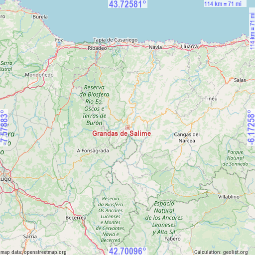
Grandas de Salime GPS coordinates[2]
43° 12' 55.944" North, 6° 52' 32.52" West
| Map corner | latitude | longitude |
|---|---|---|
| Upper-left | 43.72581°, | -7.57883° |
| Center: | 43.21554°, | -6.8757° |
| Lower-right: | 42.70096°, | -6.17258° |
| Map W x H: | 114×114 km | = 70.8×70.8mi |
| max Lat: | 43.74134° ⇑3.5% North |
| Grandas de Salime: | 43.21554° |
| min Lat: | ⇓96.5% South 27.64134° |
| min Long | Grandas de Sali | max Long |
| -18.00367° | -6.8757° | 4.2899° |
| W 6.1%⇐ | ⇒93.9% E |
Elevation
Elevation of Grandas de Salime is 554 m = 1818 ft, and this is 44 m = 144 ft below average elevation for this country.
| Max E: |
1682 m = 5518 ft | 57.8% |
| Avg. | 598 m = 1962 ft | |
| Grandas de Salime | 554 m = 1818 ft | |
Min E: |
0 m = 0 ft | 42.2% |
See also: Spain elevation on elevation.city.
Geographical zone
Grandas de Salime is located in North temperate zone (between Tropic of Cancer and the Arctic Circle). Distance of this Northern Tropic circle is 2199.2 km =1366.5 mi to South.| Distance of | km | miles | from Grandas de Salime |
|---|---|---|---|
| North Pole | 5201.9 | 3232.3 | to North |
| Arctic Circle | 2596.1 | 1613.1 | to North |
| Tropic Cancer | 2199.2 | 1366.5 | to South |
| Equator | 4805.1 | 2985.7 | to South |


Nearby cities:
15 places around Grandas de Salime: (largest is in red/bold)
• Boal
24.6 km =15.3 mi,  11°
11°
• Cangas del Narcea
26.6 km =16.5 mi,  97°
97°
• Fonsagrada
18.6 km =11.6 mi,  236°
236°
• Illano
13.2 km =8.2 mi,  3°
3°
• Navia de Suarna
29.5 km =18.3 mi,  200°
200°
• Pesoz
3.9 km =2.4 mi, 10°
• Piquín
27.3 km =17 mi,  256°
256°
• Pola de Allande
21.6 km =13.4 mi,  72°
72°
• Puente Nuevo
29.8 km =18.5 mi,  299°
299°
• San Antolín
19.7 km =12.2 mi,  179°
179°
• San Martín de Oscos
9 km =5.6 mi,  308°
308°
• Santa Eulalia de Oscos
12.6 km =7.8 mi,  292°
292°
• Taramundi
24.8 km =15.4 mi, 310°
• Vilaión
29.3 km =18.2 mi,  28°
28°
• Villanueva de Oscos
13.9 km =8.6 mi,  319°
319°
Sources, notices
• [Note1] Compared only with cities in Spain existing in our database
• [Src1] Map data: © OpenStreetMap contributors (CC-BY-SA)
• [Src2] Other city data from geonames.org with taken over terms of usage.
• [Src3] Geographical zone / Annual Mean Temperature by Robert A. Rohde @ Wikipedia
