Illano geodata
Illano (Asturias) is a seat of a third-order administrative division; located in Spain in Europe/Madrid (GMT+2) time zone. With population of 565 people, there are 3697 cities with bigger population in this country. Compared to other cities in Spain, 98.1% of cities are located further ↓South; 93.8% of cities are located further →East and 67.9% of cities have higher elevation than Illano. Note1


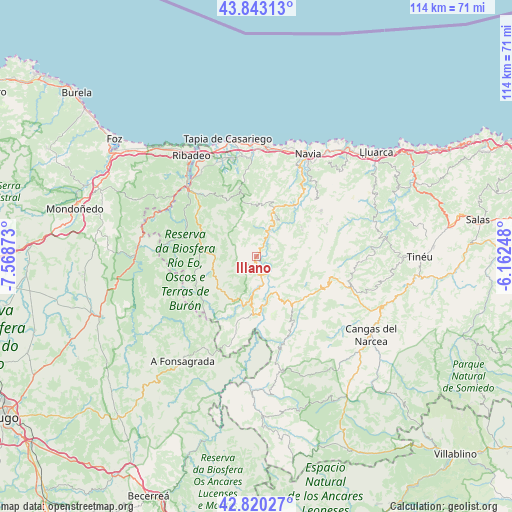
Illano GPS coordinates[2]
43° 20' 1.86" North, 6° 51' 56.16" West
| Map corner | latitude | longitude |
|---|---|---|
| Upper-left | 43.84313°, | -7.56873° |
| Center: | 43.33385°, | -6.8656° |
| Lower-right: | 42.82027°, | -6.16248° |
| Map W x H: | 113.7×113.7 km | = 70.6×70.6mi |
| max Lat: | 43.74134° ⇑1.9% North |
| Illano: | 43.33385° |
| min Lat: | ⇓98.1% South 27.64134° |
| min Long | Illano | max Long |
| -18.00367° | -6.8656° | 4.2899° |
| W 6.2%⇐ | ⇒93.8% E |
Elevation
Elevation of Illano is 419 m = 1375 ft, and this is 179 m = 587 ft below average elevation for this country.
| Max E: |
1682 m = 5518 ft | 67.9% |
| Avg. | 598 m = 1962 ft | |
| Illano | 419 m = 1375 ft | |
Min E: |
0 m = 0 ft | 32.1% |
See also: Spain elevation on elevation.city.
Geographical zone
Illano is located in North temperate zone (between Tropic of Cancer and the Arctic Circle). Distance of this Northern Tropic circle is 2212.4 km =1374.7 mi to South.| Distance of | km | miles | from Illano |
|---|---|---|---|
| North Pole | 5188.8 | 3224.2 | to North |
| Arctic Circle | 2582.9 | 1604.9 | to North |
| Tropic Cancer | 2212.4 | 1374.7 | to South |
| Equator | 4818.3 | 2994 | to South |


Nearby cities:
15 places around Illano: (largest is in red/bold)
• Boal
11.7 km =7.3 mi,  20°
20°
• Castropol
25.3 km =15.7 mi,  328°
328°
• Coaña
21.9 km =13.6 mi, 23°
• El Franco
24.6 km =15.3 mi,  359°
359°
• Grandas de Salime
13.2 km =8.2 mi,  183°
183°
• Navia
25.3 km =15.7 mi,  27°
27°
• Pesoz
9.3 km =5.8 mi, 180°
• Pola de Allande
20.9 km =13 mi,  108°
108°
• San Martín de Oscos
10.9 km =6.8 mi,  226°
226°
• San Tirso de Abres
23.9 km =14.9 mi,  290°
290°
• Santa Eulalia de Oscos
14.9 km =9.3 mi,  236°
236°
• Taramundi
19.8 km =12.3 mi,  278°
278°
• Vegadeo
21.3 km =13.2 mi,  314°
314°
• Vilaión
18.2 km =11.3 mi,  45°
45°
• Villanueva de Oscos
10.1 km =6.3 mi,  255°
255°
Sources, notices
• [Note1] Compared only with cities in Spain existing in our database
• [Src1] Map data: © OpenStreetMap contributors (CC-BY-SA)
• [Src2] Other city data from geonames.org with taken over terms of usage.
• [Src3] Geographical zone / Annual Mean Temperature by Robert A. Rohde @ Wikipedia
