Puente Nuevo geodata
Puente Nuevo (Galicia) is a populated place; located in Spain in Europe/Madrid (GMT+2) time zone. With population of 3,199 people, there are 1661 cities with bigger population in this country. Compared to other cities in Spain, 98.2% of cities are located further ↓South; 94.7% of cities are located further →East and 86.4% of cities have higher elevation than Puente Nuevo. Note1


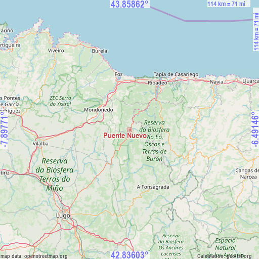
Puente Nuevo GPS coordinates[2]
43° 20' 58.128" North, 7° 11' 40.488" West
| Map corner | latitude | longitude |
|---|---|---|
| Upper-left | 43.85862°, | -7.89771° |
| Center: | 43.34948°, | -7.19458° |
| Lower-right: | 42.83603°, | -6.49146° |
| Map W x H: | 113.7×113.7 km | = 70.6×70.6mi |
| max Lat: | 43.74134° ⇑1.8% North |
| Puente Nuevo: | 43.34948° |
| min Lat: | ⇓98.2% South 27.64134° |
| min Long | Puente Nuevo | max Long |
| -18.00367° | -7.19458° | 4.2899° |
| W 5.3%⇐ | ⇒94.7% E |
Elevation
Elevation of Puente Nuevo is 117 m = 384 ft, and this is 481 m = 1578 ft below average elevation for this country.
| Max E: |
1682 m = 5518 ft | 86.4% |
| Avg. | 598 m = 1962 ft | |
| Puente Nuevo | 117 m = 384 ft | |
Min E: |
0 m = 0 ft | 13.6% |
See also: Spain elevation on elevation.city.
Geographical zone
Puente Nuevo is located in North temperate zone (between Tropic of Cancer and the Arctic Circle). Distance of this Northern Tropic circle is 2214.1 km =1375.8 mi to South.| Distance of | km | miles | from Puente Nuevo |
|---|---|---|---|
| North Pole | 5187.1 | 3223.1 | to North |
| Arctic Circle | 2581.2 | 1603.9 | to North |
| Tropic Cancer | 2214.1 | 1375.8 | to South |
| Equator | 4820 | 2995 | to South |


Nearby cities:
15 places around Puente Nuevo: (largest is in red/bold)
• Abadín
23.4 km =14.5 mi,  274°
274°
• Barreiros
20.7 km =12.9 mi,  351°
351°
• Castro de Rei
22.9 km =14.2 mi,  226°
226°
• Meira
17.1 km =10.6 mi,  207°
207°
• Mondoñedo
15.8 km =9.8 mi,  303°
303°
• Mondoñedo
17.5 km =10.9 mi,  288°
288°
• Piquín
21.5 km =13.4 mi,  181°
181°
• Ríotorto
3.1 km =1.9 mi, 271°
• San Martín de Oscos
21 km =13 mi,  116°
116°
• San Tirso de Abres
7.8 km =4.8 mi,  32°
32°
• Santa Eulalia de Oscos
17.4 km =10.8 mi,  125°
125°
• Taramundi
7.1 km =4.4 mi,  80°
80°
• Trabada
10.6 km =6.6 mi,  359°
359°
• Vegadeo
17.4 km =10.8 mi,  40°
40°
• Villanueva de Oscos
17.4 km =10.8 mi,  104°
104°
Sources, notices
• [Note1] Compared only with cities in Spain existing in our database
• [Src1] Map data: © OpenStreetMap contributors (CC-BY-SA)
• [Src2] Other city data from geonames.org with taken over terms of usage.
• [Src3] Geographical zone / Annual Mean Temperature by Robert A. Rohde @ Wikipedia
