Taramundi geodata
Taramundi (Asturias) is a seat of a third-order administrative division; located in Spain in Europe/Madrid (GMT+2) time zone. With population of 828 people, there are 3166 cities with bigger population in this country. Compared to other cities in Spain, 98.4% of cities are located further ↓South; 94.5% of cities are located further →East and 78.2% of cities have higher elevation than Taramundi. Note1


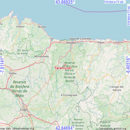
Taramundi GPS coordinates[2]
43° 21' 36.72" North, 7° 6' 29.808" West
| Map corner | latitude | longitude |
|---|---|---|
| Upper-left | 43.86925°, | -7.81141° |
| Center: | 43.3602°, | -7.10828° |
| Lower-right: | 42.84684°, | -6.40516° |
| Map W x H: | 113.7×113.7 km | = 70.6×70.6mi |
| max Lat: | 43.74134° ⇑1.6% North |
| Taramundi: | 43.3602° |
| min Lat: | ⇓98.4% South 27.64134° |
| min Long | Taramundi | max Long |
| -18.00367° | -7.10828° | 4.2899° |
| W 5.5%⇐ | ⇒94.5% E |
Elevation
Elevation of Taramundi is 251 m = 823 ft, and this is 347 m = 1138 ft below average elevation for this country.
| Max E: |
1682 m = 5518 ft | 78.2% |
| Avg. | 598 m = 1962 ft | |
| Taramundi | 251 m = 823 ft | |
Min E: |
0 m = 0 ft | 21.8% |
See also: Spain elevation on elevation.city.
Geographical zone
Taramundi is located in North temperate zone (between Tropic of Cancer and the Arctic Circle). Distance of this Northern Tropic circle is 2215.3 km =1376.5 mi to South.| Distance of | km | miles | from Taramundi |
|---|---|---|---|
| North Pole | 5185.9 | 3222.4 | to North |
| Arctic Circle | 2580 | 1603.1 | to North |
| Tropic Cancer | 2215.3 | 1376.5 | to South |
| Equator | 4821.2 | 2995.8 | to South |


Nearby cities:
15 places around Taramundi: (largest is in red/bold)
• Barreiros
21.7 km =13.5 mi,  332°
332°
• Castropol
19.7 km =12.2 mi,  18°
18°
• Figueras
21 km =13 mi, 18°
• Illano
19.8 km =12.3 mi,  98°
98°
• Meira
22.2 km =13.8 mi,  222°
222°
• Mondoñedo
21.5 km =13.4 mi,  290°
290°
• Puente Nuevo
7.1 km =4.4 mi,  260°
260°
• Ribadeo
20.4 km =12.7 mi, 15°
• Ríotorto
10.2 km =6.3 mi, 263°
• San Martín de Oscos
15.8 km =9.8 mi,  131°
131°
• San Tirso de Abres
6.1 km =3.8 mi, 332°
• Santa Eulalia de Oscos
13.3 km =8.3 mi,  147°
147°
• Trabada
11.7 km =7.3 mi,  323°
323°
• Vegadeo
12.8 km =8 mi, 20°
• Villanueva de Oscos
11.2 km =7 mi,  118°
118°
Sources, notices
• [Note1] Compared only with cities in Spain existing in our database
• [Src1] Map data: © OpenStreetMap contributors (CC-BY-SA)
• [Src2] Other city data from geonames.org with taken over terms of usage.
• [Src3] Geographical zone / Annual Mean Temperature by Robert A. Rohde @ Wikipedia
