Traiguera geodata
Traiguera (Valencia) is a seat of a third-order administrative division; located in Spain in Europe/Madrid (GMT+2) time zone. With population of 1,531 people, there are 2442 cities with bigger population in this country. Compared to other cities in Spain, 61.3% of cities are located further ↑North; 88.3% of cities are located further ←West and 76.4% of cities have higher elevation than Traiguera. Note1


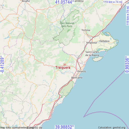
Traiguera GPS coordinates[2]
40° 31' 30.396" North, 0° 17' 24.828" East
| Map corner | latitude | longitude |
|---|---|---|
| Upper-left | 41.05744°, | -0.41289° |
| Center: | 40.52511°, | 0.29023° |
| Lower-right: | 39.98852°, | 0.99336° |
| Map W x H: | 118.9×118.9 km | = 73.9×73.9mi |
| max Lat: | 43.74134° ⇑61.3% North |
| Traiguera: | 40.52511° |
| min Lat: | ⇓38.7% South 27.64134° |
| min Long | Traiguera | max Long |
| -18.00367° | 0.29023° | 4.2899° |
| W 88.3%⇐ | ⇒11.7% E |
Elevation
Elevation of Traiguera is 280 m = 919 ft, and this is 318 m = 1043 ft below average elevation for this country.
| Max E: |
1682 m = 5518 ft | 76.4% |
| Avg. | 598 m = 1962 ft | |
| Traiguera | 280 m = 919 ft | |
Min E: |
0 m = 0 ft | 23.6% |
See also: Spain elevation on elevation.city.
Geographical zone
Traiguera is located in North temperate zone (between Tropic of Cancer and the Arctic Circle). Distance of this Northern Tropic circle is 1900.1 km =1180.7 mi to South.| Distance of | km | miles | from Traiguera |
|---|---|---|---|
| North Pole | 5501.1 | 3418.2 | to North |
| Arctic Circle | 2895.2 | 1799 | to North |
| Tropic Cancer | 1900.1 | 1180.7 | to South |
| Equator | 4506 | 2799.9 | to South |


Nearby cities:
15 places around Traiguera: (largest is in red/bold)
• Alcanar
16.2 km =10.1 mi,  82°
82°
• Benicarló
16.7 km =10.4 mi,  136°
136°
• Canet lo Roig
4.9 km =3 mi,  306°
306°
• Cervera del Maestre
8 km =5 mi,  188°
188°
• Chert/Xert
11.2 km =7 mi,  266°
266°
• Càlig
8.9 km =5.5 mi, 141°
• Godall
20.9 km =13 mi,  46°
46°
• Les Cases d'Alcanar
20.5 km =12.7 mi, 81°
• Rosell
11.8 km =7.3 mi,  330°
330°
• Salsadella
15.4 km =9.6 mi,  219°
219°
• Sant Jordi
3.9 km =2.4 mi,  115°
115°
• Sant Rafel del Maestrat
9.7 km =6 mi,  31°
31°
• Santa Magdalena de Pulpis
18.8 km =11.7 mi,  176°
176°
• Ulldecona
15.5 km =9.6 mi,  58°
58°
• Vinaròs
16.8 km =10.4 mi,  111°
111°
Sources, notices
• [Note1] Compared only with cities in Spain existing in our database
• [Src1] Map data: © OpenStreetMap contributors (CC-BY-SA)
• [Src2] Other city data from geonames.org with taken over terms of usage.
• [Src3] Geographical zone / Annual Mean Temperature by Robert A. Rohde @ Wikipedia
