Vinaròs geodata
Vinaròs (Valencia) is a seat of a third-order administrative division; located in Spain in Europe/Madrid (GMT+2) time zone. With population of 28,273 people, there are 331 cities with bigger population in this country. Compared to other cities in Spain, 62.5% of cities are located further ↑North; 88.9% of cities are located further ←West and 97.9% of cities have higher elevation than Vinaròs. Note1


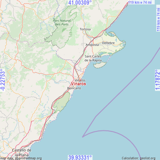
Vinaròs GPS coordinates[2]
40° 28' 13.188" North, 0° 28' 32.124" East
| Map corner | latitude | longitude |
|---|---|---|
| Upper-left | 41.00309°, | -0.22753° |
| Center: | 40.47033°, | 0.47559° |
| Lower-right: | 39.93331°, | 1.17872° |
| Map W x H: | 118.9×118.9 km | = 73.9×73.9mi |
| max Lat: | 43.74134° ⇑62.5% North |
| Vinaròs: | 40.47033° |
| min Lat: | ⇓37.5% South 27.64134° |
| min Long | Vinaròs | max Long |
| -18.00367° | 0.47559° | 4.2899° |
| W 88.9%⇐ | ⇒11.1% E |
Elevation
Elevation of Vinaròs is 12 m = 39 ft, and this is 586 m = 1923 ft below average elevation for this country.
| Max E: |
1682 m = 5518 ft | 97.9% |
| Avg. | 598 m = 1962 ft | |
| Vinaròs | 12 m = 39 ft | |
Min E: |
0 m = 0 ft | 2.1% |
See also: Spain elevation on elevation.city.
Geographical zone
Vinaròs is located in North temperate zone (between Tropic of Cancer and the Arctic Circle). Distance of this Northern Tropic circle is 1894 km =1176.9 mi to South.| Distance of | km | miles | from Vinaròs |
|---|---|---|---|
| North Pole | 5507.2 | 3422 | to North |
| Arctic Circle | 2901.3 | 1802.8 | to North |
| Tropic Cancer | 1894 | 1176.9 | to South |
| Equator | 4499.9 | 2796.1 | to South |


Nearby cities:
15 places around Vinaròs: (largest is in red/bold)
• Alcanar
8.1 km =5 mi,  3°
3°
• Benicarló
7.3 km =4.5 mi,  214°
214°
• Canet lo Roig
21.6 km =13.4 mi,  294°
294°
• Cervera del Maestre
16.9 km =10.5 mi,  263°
263°
• Càlig
10.2 km =6.3 mi,  265°
265°
• Godall
20.6 km =12.8 mi,  358°
358°
• La Galera
23.5 km =14.6 mi, 357°
• Les Cases d'Alcanar
10.3 km =6.4 mi,  26°
26°
• Peníscola
13.8 km =8.6 mi,  204°
204°
• Sant Carles de la Ràpita
19.4 km =12.1 mi, 32°
• Sant Jordi
12.9 km =8 mi, 289°
• Sant Rafel del Maestrat
17.9 km =11.1 mi,  323°
323°
• Santa Magdalena de Pulpis
19.4 km =12.1 mi,  229°
229°
• Traiguera
16.8 km =10.4 mi, 291°
• Ulldecona
14.3 km =8.9 mi,  350°
350°
Sources, notices
• [Note1] Compared only with cities in Spain existing in our database
• [Src1] Map data: © OpenStreetMap contributors (CC-BY-SA)
• [Src2] Other city data from geonames.org with taken over terms of usage.
• [Src3] Geographical zone / Annual Mean Temperature by Robert A. Rohde @ Wikipedia
