Entrena geodata
Entrena (La Rioja) is a seat of a third-order administrative division; located in Spain in Europe/Madrid (GMT+2) time zone. With population of 1,248 people, there are 2684 cities with bigger population in this country. Compared to other cities in Spain, 84.4% of cities are located further ↓South; 60.6% of cities are located further ←West and 57.8% of cities have higher elevation than Entrena. Note1


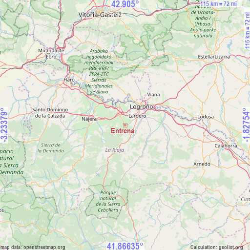
Entrena GPS coordinates[2]
42° 23' 16.152" North, 2° 31' 50.376" West
| Map corner | latitude | longitude |
|---|---|---|
| Upper-left | 42.905°, | -3.23379° |
| Center: | 42.38782°, | -2.53066° |
| Lower-right: | 41.86635°, | -1.82754° |
| Map W x H: | 115.5×115.5 km | = 71.8×71.8mi |
| max Lat: | 43.74134° ⇑15.6% North |
| Entrena: | 42.38782° |
| min Lat: | ⇓84.4% South 27.64134° |
| min Long | Entrena | max Long |
| -18.00367° | -2.53066° | 4.2899° |
| W 60.6%⇐ | ⇒39.4% E |
Elevation
Elevation of Entrena is 554 m = 1818 ft, and this is 44 m = 144 ft below average elevation for this country.
| Max E: |
1682 m = 5518 ft | 57.8% |
| Avg. | 598 m = 1962 ft | |
| Entrena | 554 m = 1818 ft | |
Min E: |
0 m = 0 ft | 42.2% |
See also: Spain elevation on elevation.city.
Geographical zone
Entrena is located in North temperate zone (between Tropic of Cancer and the Arctic Circle). Distance of this Northern Tropic circle is 2107.2 km =1309.4 mi to South.| Distance of | km | miles | from Entrena |
|---|---|---|---|
| North Pole | 5294 | 3289.5 | to North |
| Arctic Circle | 2688.1 | 1670.3 | to North |
| Tropic Cancer | 2107.2 | 1309.4 | to South |
| Equator | 4713.1 | 2928.6 | to South |


Nearby cities:
15 places around Entrena: (largest is in red/bold)
• Albelda de Iregua
5.8 km =3.6 mi,  124°
124°
• Alberite
7.8 km =4.8 mi,  74°
74°
• Clavijo
9.6 km =6 mi, 116°
• Daroca de Rioja
4.6 km =2.9 mi,  246°
246°
• Fuenmayor
9.2 km =5.7 mi,  344°
344°
• Hornos de Moncalvillo
4.5 km =2.8 mi,  275°
275°
• Lardero
7.1 km =4.4 mi,  52°
52°
• Medrano
2 km =1.2 mi,  256°
256°
• Nalda
6.9 km =4.3 mi,  148°
148°
• Navarrete
5.5 km =3.4 mi,  329°
329°
• Sojuela
2.3 km =1.4 mi,  210°
210°
• Sorzano
5 km =3.1 mi,  178°
178°
• Ventosa
8.1 km =5 mi, 283°
• Viguera
8.7 km =5.4 mi, 181°
• Villamediana de Iregua
10.1 km =6.3 mi,  64°
64°
Sources, notices
• [Note1] Compared only with cities in Spain existing in our database
• [Src1] Map data: © OpenStreetMap contributors (CC-BY-SA)
• [Src2] Other city data from geonames.org with taken over terms of usage.
• [Src3] Geographical zone / Annual Mean Temperature by Robert A. Rohde @ Wikipedia
