Torremontalbo geodata
Torremontalbo (La Rioja) is a seat of a third-order administrative division; located in Spain in Europe/Madrid (GMT+2) time zone. With population of 21 people, there are 6716 cities with bigger population in this country. Compared to other cities in Spain, 87.2% of cities are located further ↓South; 58.8% of cities are located further ←West and 67.9% of cities have higher elevation than Torremontalbo. Note1


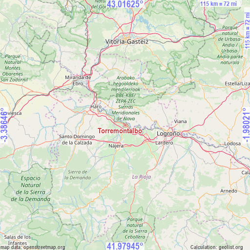
Torremontalbo GPS coordinates[2]
42° 30' 0" North, 2° 40' 59.988" West
| Map corner | latitude | longitude |
|---|---|---|
| Upper-left | 43.01625°, | -3.38646° |
| Center: | 42.5°, | -2.68333° |
| Lower-right: | 41.97945°, | -1.98021° |
| Map W x H: | 115.3×115.3 km | = 71.6×71.6mi |
| max Lat: | 43.74134° ⇑12.8% North |
| Torremontalbo: | 42.5° |
| min Lat: | ⇓87.2% South 27.64134° |
| min Long | Torremontalbo | max Long |
| -18.00367° | -2.68333° | 4.2899° |
| W 58.8%⇐ | ⇒41.2% E |
Elevation
Elevation of Torremontalbo is 419 m = 1375 ft, and this is 179 m = 587 ft below average elevation for this country.
| Max E: |
1682 m = 5518 ft | 67.9% |
| Avg. | 598 m = 1962 ft | |
| Torremontalbo | 419 m = 1375 ft | |
Min E: |
0 m = 0 ft | 32.1% |
See also: Spain elevation on elevation.city.
Geographical zone
Torremontalbo is located in North temperate zone (between Tropic of Cancer and the Arctic Circle). Distance of this Northern Tropic circle is 2119.6 km =1317.1 mi to South.| Distance of | km | miles | from Torremontalbo |
|---|---|---|---|
| North Pole | 5281.5 | 3281.8 | to North |
| Arctic Circle | 2675.6 | 1662.5 | to North |
| Tropic Cancer | 2119.6 | 1317.1 | to South |
| Equator | 4725.6 | 2936.4 | to South |


Nearby cities:
15 places around Torremontalbo: (largest is in red/bold)
• Briones
9.7 km =6 mi,  300°
300°
• Cenicero
3.8 km =2.4 mi,  122°
122°
• Elciego
5.6 km =3.5 mi,  71°
71°
• Eskuernaga / Villabuena de Álava
5.5 km =3.4 mi,  15°
15°
• Hormilleja
6.3 km =3.9 mi,  219°
219°
• Huércanos
8.1 km =5 mi,  187°
187°
• Lapuebla de Labarca
9 km =5.6 mi,  93°
93°
• Leza
8.4 km =5.2 mi,  29°
29°
• Navaridas
6.9 km =4.3 mi,  42°
42°
• Nájera
9.8 km =6.1 mi,  202°
202°
• Samaniego
7.6 km =4.7 mi,  2°
2°
• San Asensio
5.5 km =3.4 mi,  266°
266°
• San Vicente de la Sonsierra
9.5 km =5.9 mi,  317°
317°
• Uruñuela
6.6 km =4.1 mi, 197°
• Ábalos
8.2 km =5.1 mi,  344°
344°
Sources, notices
• [Note1] Compared only with cities in Spain existing in our database
• [Src1] Map data: © OpenStreetMap contributors (CC-BY-SA)
• [Src2] Other city data from geonames.org with taken over terms of usage.
• [Src3] Geographical zone / Annual Mean Temperature by Robert A. Rohde @ Wikipedia
