Fuencemillán geodata
Fuencemillán (Castille-La Mancha) is a seat of a third-order administrative division; located in Spain in Europe/Madrid (GMT+2) time zone. With population of 103 people, there are 5896 cities with bigger population in this country. Compared to other cities in Spain, 53.4% of cities are located further ↑North; 52.8% of cities are located further ←West and 68% of cities have lower elevation than Fuencemillán. Note1
Administrative division(s):
- Level 1: Castille-La Mancha
- Level 2: Provincia de Guadalajara
- Level 3: Fuencemillán


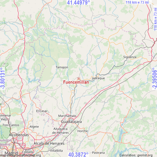
Fuencemillán GPS coordinates[2]
40° 55' 14.268" North, 3° 5' 53.448" West
| Map corner | latitude | longitude |
|---|---|---|
| Upper-left | 41.44979°, | -3.80131° |
| Center: | 40.92063°, | -3.09818° |
| Lower-right: | 40.3872°, | -2.39506° |
| Map W x H: | 118.1×118.1 km | = 73.4×73.4mi |
| max Lat: | 43.74134° ⇑53.4% North |
| Fuencemillán: | 40.92063° |
| min Lat: | ⇓46.6% South 27.64134° |
| min Long | Fuencemillán | max Long |
| -18.00367° | -3.09818° | 4.2899° |
| W 52.8%⇐ | ⇒47.2% E |
Elevation
Elevation of Fuencemillán is 799 m = 2621 ft, and this is 201 m = 659 ft above average elevation for this country.
| Max E: |
1682 m = 5518 ft | 32% |
| Fuencemillán | 799 m 2621 ft | |
| Avg. | 598 m = 1962 ft | |
Min E: |
0 m = 0 ft | 68% |
See also: Spain elevation on elevation.city.
Geographical zone
Fuencemillán is located in North temperate zone (between Tropic of Cancer and the Arctic Circle). Distance of this Northern Tropic circle is 1944 km =1207.9 mi to South.| Distance of | km | miles | from Fuencemillán |
|---|---|---|---|
| North Pole | 5457.1 | 3390.9 | to North |
| Arctic Circle | 2851.2 | 1771.7 | to North |
| Tropic Cancer | 1944 | 1207.9 | to South |
| Equator | 4549.9 | 2827.2 | to South |


Nearby cities:
15 places around Fuencemillán: (largest is in red/bold)
• Alarilla
8.2 km =5.1 mi,  182°
182°
• Arbancón
5.1 km =3.2 mi,  343°
343°
• Casas de San Galindo
13 km =8.1 mi,  114°
114°
• Cogolludo
3 km =1.9 mi,  14°
14°
• Copernal
7.3 km =4.5 mi,  149°
149°
• Espinosa de Henares
3.3 km =2.1 mi,  132°
132°
• Hita
11.9 km =7.4 mi,  158°
158°
• Humanes
11.5 km =7.1 mi,  203°
203°
• Membrillera
10.4 km =6.5 mi,  72°
72°
• Miralrío
13.5 km =8.4 mi, 105°
• Monasterio
7.2 km =4.5 mi,  0°
0°
• Montarrón
2.1 km =1.3 mi,  222°
222°
• Puebla de Beleña
10.6 km =6.6 mi,  249°
249°
• San Andrés del Congosto
10.6 km =6.6 mi,  35°
35°
• Taragudo
11.2 km =7 mi,  170°
170°
Sources, notices
• [Note1] Compared only with cities in Spain existing in our database
• [Src1] Map data: © OpenStreetMap contributors (CC-BY-SA)
• [Src2] Other city data from geonames.org with taken over terms of usage.
• [Src3] Geographical zone / Annual Mean Temperature by Robert A. Rohde @ Wikipedia
