Cogolludo geodata
Cogolludo (Castille-La Mancha) is a seat of a third-order administrative division; located in Spain in Europe/Madrid (GMT+2) time zone. With population of 633 people, there are 3540 cities with bigger population in this country. Compared to other cities in Spain, 52.9% of cities are located further ↑North; 52.9% of cities are located further ←West and 78.1% of cities have lower elevation than Cogolludo. Note1
Administrative division(s):
- Level 1: Castille-La Mancha
- Level 2: Provincia de Guadalajara
- Level 3: Cogolludo


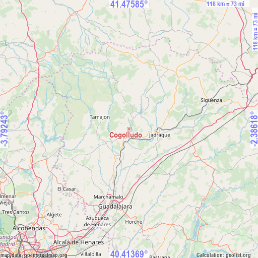
Cogolludo GPS coordinates[2]
40° 56' 48.876" North, 3° 5' 21.48" West
| Map corner | latitude | longitude |
|---|---|---|
| Upper-left | 41.47585°, | -3.79243° |
| Center: | 40.94691°, | -3.0893° |
| Lower-right: | 40.41369°, | -2.38618° |
| Map W x H: | 118.1×118.1 km | = 73.4×73.4mi |
| max Lat: | 43.74134° ⇑52.9% North |
| Cogolludo: | 40.94691° |
| min Lat: | ⇓47.1% South 27.64134° |
| min Long | Cogolludo | max Long |
| -18.00367° | -3.0893° | 4.2899° |
| W 52.9%⇐ | ⇒47.1% E |
Elevation
Elevation of Cogolludo is 880 m = 2887 ft, and this is 282 m = 925 ft above average elevation for this country.
| Max E: |
1682 m = 5518 ft | 21.9% |
| Cogolludo | 880 m 2887 ft | |
| Avg. | 598 m = 1962 ft | |
Min E: |
0 m = 0 ft | 78.1% |
See also: Spain elevation on elevation.city.
Geographical zone
Cogolludo is located in North temperate zone (between Tropic of Cancer and the Arctic Circle). Distance of this Northern Tropic circle is 1947 km =1209.8 mi to South.| Distance of | km | miles | from Cogolludo |
|---|---|---|---|
| North Pole | 5454.2 | 3389.1 | to North |
| Arctic Circle | 2848.3 | 1769.9 | to North |
| Tropic Cancer | 1947 | 1209.8 | to South |
| Equator | 4552.9 | 2829 | to South |


Nearby cities:
15 places around Cogolludo: (largest is in red/bold)
• Alarilla
11.2 km =7 mi,  185°
185°
• Arbancón
2.9 km =1.8 mi,  311°
311°
• Casas de San Galindo
13.8 km =8.6 mi,  126°
126°
• Congostrina
13.3 km =8.3 mi,  40°
40°
• Copernal
9.6 km =6 mi,  162°
162°
• Espinosa de Henares
5.4 km =3.4 mi, 162°
• Fuencemillán
3 km =1.9 mi, 194°
• Medranda
13.4 km =8.3 mi,  72°
72°
• Membrillera
9.2 km =5.7 mi,  89°
89°
• Miralrío
13.8 km =8.6 mi,  117°
117°
• Monasterio
4.3 km =2.7 mi,  351°
351°
• Montarrón
5 km =3.1 mi,  205°
205°
• Puebla de Beleña
12.5 km =7.8 mi,  238°
238°
• San Andrés del Congosto
7.9 km =4.9 mi, 44°
• Semillas
12.7 km =7.9 mi, 348°
Sources, notices
• [Note1] Compared only with cities in Spain existing in our database
• [Src1] Map data: © OpenStreetMap contributors (CC-BY-SA)
• [Src2] Other city data from geonames.org with taken over terms of usage.
• [Src3] Geographical zone / Annual Mean Temperature by Robert A. Rohde @ Wikipedia
