Fresnedoso geodata
Fresnedoso (Castille and León) is a seat of a third-order administrative division; located in Spain in Europe/Madrid (GMT+2) time zone. With population of 129 people, there are 5591 cities with bigger population in this country. Compared to other cities in Spain, 63.2% of cities are located further ↑North; 81.9% of cities are located further →East and 89.3% of cities have lower elevation than Fresnedoso. Note1
Administrative division(s):
- Level 1: Castille and León
- Level 2: Provincia de Salamanca
- Level 3: Fresnedoso


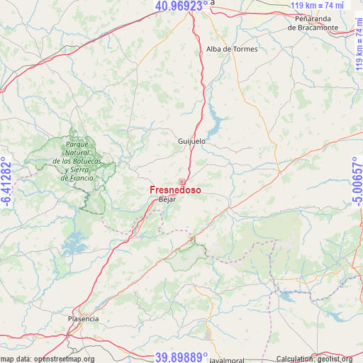
Fresnedoso GPS coordinates[2]
40° 26' 10.284" North, 5° 42' 34.884" West
| Map corner | latitude | longitude |
|---|---|---|
| Upper-left | 40.96923°, | -6.41282° |
| Center: | 40.43619°, | -5.70969° |
| Lower-right: | 39.89889°, | -5.00657° |
| Map W x H: | 119×119 km | = 73.9×73.9mi |
| max Lat: | 43.74134° ⇑63.2% North |
| Fresnedoso: | 40.43619° |
| min Lat: | ⇓36.8% South 27.64134° |
| min Long | Fresnedoso | max Long |
| -18.00367° | -5.70969° | 4.2899° |
| W 18.1%⇐ | ⇒81.9% E |
Elevation
Elevation of Fresnedoso is 1020 m = 3346 ft, and this is 422 m = 1385 ft above average elevation for this country.
| Max E: |
1682 m = 5518 ft | 10.7% |
| Fresnedoso | 1020 m 3346 ft | |
| Avg. | 598 m = 1962 ft | |
Min E: |
0 m = 0 ft | 89.3% |
See also: Spain elevation on elevation.city.
Geographical zone
Fresnedoso is located in North temperate zone (between Tropic of Cancer and the Arctic Circle). Distance of this Northern Tropic circle is 1890.2 km =1174.5 mi to South.| Distance of | km | miles | from Fresnedoso |
|---|---|---|---|
| North Pole | 5511 | 3424.4 | to North |
| Arctic Circle | 2905.1 | 1805.1 | to North |
| Tropic Cancer | 1890.2 | 1174.5 | to South |
| Equator | 4496.1 | 2793.7 | to South |


Nearby cities:
15 places around Fresnedoso: (largest is in red/bold)
• Becedas
7.2 km =4.5 mi,  120°
120°
• Béjar
7.2 km =4.5 mi,  219°
219°
• Fuentes de Béjar
8.1 km =5 mi,  10°
10°
• Ledrada
3.7 km =2.3 mi,  345°
345°
• Medinilla
7.8 km =4.8 mi,  87°
87°
• Nava de Béjar
5.1 km =3.2 mi,  31°
31°
• Navacarros
4.3 km =2.7 mi,  185°
185°
• Navalmoral de Béjar
6.4 km =4 mi,  256°
256°
• Neila de San Miguel
5.2 km =3.2 mi,  105°
105°
• Peromingo
6.1 km =3.8 mi,  300°
300°
• San Bartolomé de Béjar
5.1 km =3.2 mi,  128°
128°
• Sanchotello
3.8 km =2.4 mi,  273°
273°
• Sorihuela
2.8 km =1.7 mi,  72°
72°
• Vallejera de Riofrío
3.1 km =1.9 mi,  195°
195°
• Valverde de Valdelacasa
7.9 km =4.9 mi,  309°
309°
Sources, notices
• [Note1] Compared only with cities in Spain existing in our database
• [Src1] Map data: © OpenStreetMap contributors (CC-BY-SA)
• [Src2] Other city data from geonames.org with taken over terms of usage.
• [Src3] Geographical zone / Annual Mean Temperature by Robert A. Rohde @ Wikipedia
