Becedas geodata
Becedas (Castille and León) is a seat of a third-order administrative division; located in Spain in Europe/Madrid (GMT+2) time zone. With population of 338 people, there are 4357 cities with bigger population in this country. Compared to other cities in Spain, 63.9% of cities are located further ↑North; 80.7% of cities are located further →East and 93.5% of cities have lower elevation than Becedas. Note1


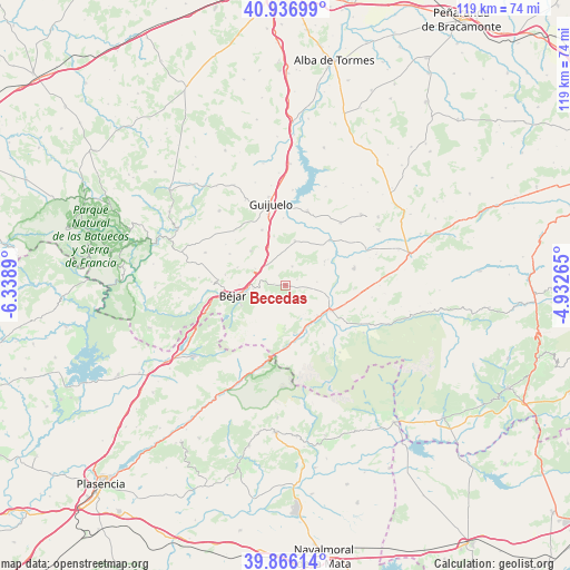
Becedas GPS coordinates[2]
40° 24' 13.284" North, 5° 38' 8.772" West
| Map corner | latitude | longitude |
|---|---|---|
| Upper-left | 40.93699°, | -6.3389° |
| Center: | 40.40369°, | -5.63577° |
| Lower-right: | 39.86614°, | -4.93265° |
| Map W x H: | 119.1×119.1 km | = 74×74mi |
| max Lat: | 43.74134° ⇑63.9% North |
| Becedas: | 40.40369° |
| min Lat: | ⇓36.1% South 27.64134° |
| min Long | Becedas | max Long |
| -18.00367° | -5.63577° | 4.2899° |
| W 19.3%⇐ | ⇒80.7% E |
Elevation
Elevation of Becedas is 1106 m = 3629 ft, and this is 508 m = 1667 ft above average elevation for this country.
| Max E: |
1682 m = 5518 ft | 6.5% |
| Becedas | 1106 m 3629 ft | |
| Avg. | 598 m = 1962 ft | |
Min E: |
0 m = 0 ft | 93.5% |
See also: Spain elevation on elevation.city.
Geographical zone
Becedas is located in North temperate zone (between Tropic of Cancer and the Arctic Circle). Distance of this Northern Tropic circle is 1886.6 km =1172.3 mi to South.| Distance of | km | miles | from Becedas |
|---|---|---|---|
| North Pole | 5514.6 | 3426.6 | to North |
| Arctic Circle | 2908.7 | 1807.4 | to North |
| Tropic Cancer | 1886.6 | 1172.3 | to South |
| Equator | 4492.5 | 2791.5 | to South |


Nearby cities:
15 places around Becedas: (largest is in red/bold)
• Candelario
10.1 km =6.3 mi,  246°
246°
• El Barco de Ávila
10.8 km =6.7 mi,  118°
118°
• Fresnedoso
7.2 km =4.5 mi,  300°
300°
• Junciana
6.7 km =4.2 mi,  83°
83°
• La Carrera
9.3 km =5.8 mi,  132°
132°
• Ledrada
10.2 km =6.3 mi,  315°
315°
• Medinilla
4.3 km =2.7 mi,  20°
20°
• Nava de Béjar
8.7 km =5.4 mi,  335°
335°
• Navacarros
6.7 km =4.2 mi,  264°
264°
• Neila de San Miguel
2.6 km =1.6 mi,  330°
330°
• San Bartolomé de Béjar
2.3 km =1.4 mi,  281°
281°
• Sanchotello
10.7 km =6.6 mi,  290°
290°
• Santibáñez de Béjar
9.6 km =6 mi,  12°
12°
• Sorihuela
5.7 km =3.5 mi, 321°
• Vallejera de Riofrío
7.1 km =4.4 mi,  274°
274°
Sources, notices
• [Note1] Compared only with cities in Spain existing in our database
• [Src1] Map data: © OpenStreetMap contributors (CC-BY-SA)
• [Src2] Other city data from geonames.org with taken over terms of usage.
• [Src3] Geographical zone / Annual Mean Temperature by Robert A. Rohde @ Wikipedia
