Bellpuig geodata
Bellpuig (Catalonia) is a seat of a third-order administrative division; located in Spain in Europe/Madrid (GMT+2) time zone. With population of 4,269 people, there are 1426 cities with bigger population in this country. Compared to other cities in Spain, 64.1% of cities are located further ↓South; 90.5% of cities are located further ←West and 74.3% of cities have higher elevation than Bellpuig. Note1


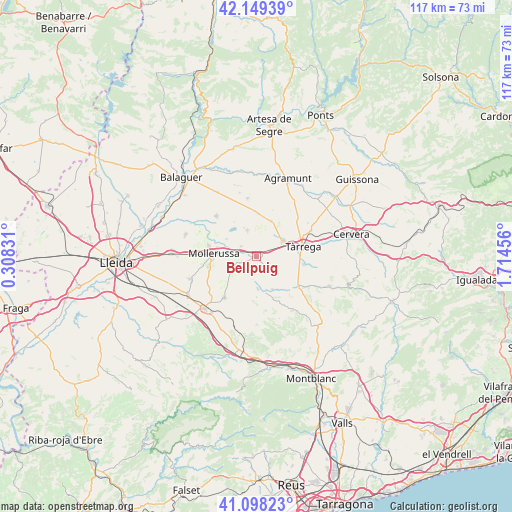
Bellpuig GPS coordinates[2]
41° 37' 33.42" North, 1° 0' 41.184" East
| Map corner | latitude | longitude |
|---|---|---|
| Upper-left | 42.14939°, | 0.30831° |
| Center: | 41.62595°, | 1.01144° |
| Lower-right: | 41.09823°, | 1.71456° |
| Map W x H: | 116.9×116.9 km | = 72.6×72.6mi |
| max Lat: | 43.74134° ⇑35.9% North |
| Bellpuig: | 41.62595° |
| min Lat: | ⇓64.1% South 27.64134° |
| min Long | Bellpuig | max Long |
| -18.00367° | 1.01144° | 4.2899° |
| W 90.5%⇐ | ⇒9.5% E |
Elevation
Elevation of Bellpuig is 308 m = 1010 ft, and this is 290 m = 951 ft below average elevation for this country.
| Max E: |
1682 m = 5518 ft | 74.3% |
| Avg. | 598 m = 1962 ft | |
| Bellpuig | 308 m = 1010 ft | |
Min E: |
0 m = 0 ft | 25.7% |
See also: Spain elevation on elevation.city.
Geographical zone
Bellpuig is located in North temperate zone (between Tropic of Cancer and the Arctic Circle). Distance of this Northern Tropic circle is 2022.5 km =1256.7 mi to South.| Distance of | km | miles | from Bellpuig |
|---|---|---|---|
| North Pole | 5378.7 | 3342.2 | to North |
| Arctic Circle | 2772.8 | 1722.9 | to North |
| Tropic Cancer | 2022.5 | 1256.7 | to South |
| Equator | 4628.4 | 2876 | to South |


Nearby cities:
15 places around Bellpuig: (largest is in red/bold)
• Anglesola
6.8 km =4.2 mi,  60°
60°
• Barbens
5.9 km =3.7 mi,  4°
4°
• Belianes
7.3 km =4.5 mi,  177°
177°
• Castellnou de Seana
4.2 km =2.6 mi,  306°
306°
• Fondarella
11.5 km =7.1 mi,  274°
274°
• Golmés
6.7 km =4.2 mi,  277°
277°
• Ivars d'Urgell
6.4 km =4 mi,  341°
341°
• La Fuliola
9.8 km =6.1 mi, 2°
• Linyola
11.4 km =7.1 mi,  316°
316°
• Miralcamp
11.2 km =7 mi,  258°
258°
• Mollerussa
9.3 km =5.8 mi, 275°
• Tornabous
9.1 km =5.7 mi,  22°
22°
• Tàrrega
10.9 km =6.8 mi,  77°
77°
• Verdú
11.1 km =6.9 mi,  98°
98°
• Vilanova de Bellpuig
4.1 km =2.5 mi,  250°
250°
Sources, notices
• [Note1] Compared only with cities in Spain existing in our database
• [Src1] Map data: © OpenStreetMap contributors (CC-BY-SA)
• [Src2] Other city data from geonames.org with taken over terms of usage.
• [Src3] Geographical zone / Annual Mean Temperature by Robert A. Rohde @ Wikipedia
