Illana geodata
Illana (Castille-La Mancha) is a seat of a third-order administrative division; located in Spain in Europe/Madrid (GMT+2) time zone. With population of 756 people, there are 3293 cities with bigger population in this country. Compared to other cities in Spain, 67.5% of cities are located further ↑North; 55.8% of cities are located further ←West and 60.2% of cities have lower elevation than Illana. Note1
Administrative division(s):
- Level 1: Castille-La Mancha
- Level 2: Provincia de Guadalajara
- Level 3: Illana


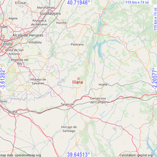
Illana GPS coordinates[2]
40° 11' 3.912" North, 2° 54' 32.004" West
| Map corner | latitude | longitude |
|---|---|---|
| Upper-left | 40.71946°, | -3.61202° |
| Center: | 40.18442°, | -2.90889° |
| Lower-right: | 39.64513°, | -2.20577° |
| Map W x H: | 119.5×119.5 km | = 74.3×74.3mi |
| max Lat: | 43.74134° ⇑67.5% North |
| Illana: | 40.18442° |
| min Lat: | ⇓32.5% South 27.64134° |
| min Long | Illana | max Long |
| -18.00367° | -2.90889° | 4.2899° |
| W 55.8%⇐ | ⇒44.2% E |
Elevation
Elevation of Illana is 746 m = 2448 ft, and this is 148 m = 486 ft above average elevation for this country.
| Max E: |
1682 m = 5518 ft | 39.8% |
| Illana | 746 m 2448 ft | |
| Avg. | 598 m = 1962 ft | |
Min E: |
0 m = 0 ft | 60.2% |
See also: Spain elevation on elevation.city.
Geographical zone
Illana is located in North temperate zone (between Tropic of Cancer and the Arctic Circle). Distance of this Northern Tropic circle is 1862.2 km =1157.1 mi to South.| Distance of | km | miles | from Illana |
|---|---|---|---|
| North Pole | 5539 | 3441.8 | to North |
| Arctic Circle | 2933.1 | 1822.5 | to North |
| Tropic Cancer | 1862.2 | 1157.1 | to South |
| Equator | 4468.1 | 2776.3 | to South |


Nearby cities:
15 places around Illana: (largest is in red/bold)
• Albalate de Zorita
14.9 km =9.3 mi,  22°
22°
• Albares
16.1 km =10 mi,  328°
328°
• Alcázar del Rey
16 km =9.9 mi,  147°
147°
• Almoguera
14 km =8.7 mi, 333°
• Almonacid de Zorita
16.9 km =10.5 mi, 17°
• Barajas de Melo
6.8 km =4.2 mi,  185°
185°
• Driebes
13.1 km =8.1 mi,  300°
300°
• Estremera
16.2 km =10.1 mi,  269°
269°
• Huelves
15.9 km =9.9 mi,  172°
172°
• Leganiel
4 km =2.5 mi,  238°
238°
• Mazuecos
11.9 km =7.4 mi,  315°
315°
• Paredes
14 km =8.7 mi,  160°
160°
• Saceda-Trasierra
5.7 km =3.5 mi,  124°
124°
• Vellisca
10.1 km =6.3 mi,  127°
127°
• Zorita de los Canes
16.3 km =10.1 mi,  6°
6°
Sources, notices
• [Note1] Compared only with cities in Spain existing in our database
• [Src1] Map data: © OpenStreetMap contributors (CC-BY-SA)
• [Src2] Other city data from geonames.org with taken over terms of usage.
• [Src3] Geographical zone / Annual Mean Temperature by Robert A. Rohde @ Wikipedia
