Almoguera geodata
Almoguera (Castille-La Mancha) is a seat of a third-order administrative division; located in Spain in Europe/Madrid (GMT+2) time zone. In our database, there are 6762 cities with bigger population. Compared to other cities in Spain, 65.9% of cities are located further ↑North; 54.8% of cities are located further ←West and 50.2% of cities have lower elevation than Almoguera. Note1
Administrative division(s):
- Level 1: Castille-La Mancha
- Level 2: Provincia de Guadalajara
- Level 3: Almoguera


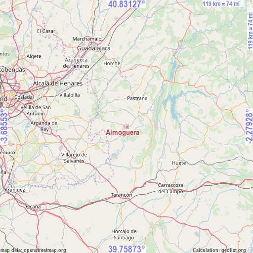
Almoguera GPS coordinates[2]
40° 17' 49.668" North, 2° 58' 56.64" West
| Map corner | latitude | longitude |
|---|---|---|
| Upper-left | 40.83127°, | -3.68553° |
| Center: | 40.29713°, | -2.9824° |
| Lower-right: | 39.75873°, | -2.27928° |
| Map W x H: | 119.3×119.3 km | = 74.1×74.1mi |
| max Lat: | 43.74134° ⇑65.9% North |
| Almoguera: | 40.29713° |
| min Lat: | ⇓34.1% South 27.64134° |
| min Long | Almoguera | max Long |
| -18.00367° | -2.9824° | 4.2899° |
| W 54.8%⇐ | ⇒45.2% E |
Elevation
Elevation of Almoguera is 660 m = 2165 ft, and this is 62 m = 203 ft above average elevation for this country.
| Max E: |
1682 m = 5518 ft | 49.8% |
| Almoguera | 660 m 2165 ft | |
| Avg. | 598 m = 1962 ft | |
Min E: |
0 m = 0 ft | 50.2% |
See also: Spain elevation on elevation.city.
Geographical zone
Almoguera is located in North temperate zone (between Tropic of Cancer and the Arctic Circle). Distance of this Northern Tropic circle is 1874.7 km =1164.9 mi to South.| Distance of | km | miles | from Almoguera |
|---|---|---|---|
| North Pole | 5526.4 | 3433.9 | to North |
| Arctic Circle | 2920.6 | 1814.8 | to North |
| Tropic Cancer | 1874.7 | 1164.9 | to South |
| Equator | 4480.6 | 2784.1 | to South |


Nearby cities:
15 places around Almoguera: (largest is in red/bold)
• Albalate de Zorita
11.9 km =7.4 mi,  84°
84°
• Albares
2.5 km =1.6 mi,  295°
295°
• Almonacid de Zorita
11.7 km =7.3 mi,  72°
72°
• Brea de Tajo
12.2 km =7.6 mi,  234°
234°
• Driebes
7.7 km =4.8 mi,  220°
220°
• Escariche
13.5 km =8.4 mi,  333°
333°
• Escopete
13 km =8.1 mi,  351°
351°
• Fuentenovilla
11.7 km =7.3 mi,  308°
308°
• Illana
14 km =8.7 mi,  153°
153°
• Mazuecos
4.6 km =2.9 mi,  207°
207°
• Mondéjar
10.9 km =6.8 mi,  284°
284°
• Pozo de Almoguera
6.1 km =3.8 mi,  322°
322°
• Sayatón
14.1 km =8.8 mi,  51°
51°
• Yebra
6.8 km =4.2 mi,  11°
11°
• Zorita de los Canes
8.9 km =5.5 mi, 65°
Sources, notices
• [Note1] Compared only with cities in Spain existing in our database
• [Src1] Map data: © OpenStreetMap contributors (CC-BY-SA)
• [Src2] Other city data from geonames.org with taken over terms of usage.
• [Src3] Geographical zone / Annual Mean Temperature by Robert A. Rohde @ Wikipedia
