Elgoibar geodata
Elgoibar (Basque Country) is a seat of a third-order administrative division; located in Spain in Europe/Madrid (GMT+2) time zone. With population of 11,220 people, there are 783 cities with bigger population in this country. Compared to other cities in Spain, 96.6% of cities are located further ↓South; 62.1% of cities are located further ←West and 91.5% of cities have higher elevation than Elgoibar. Note1


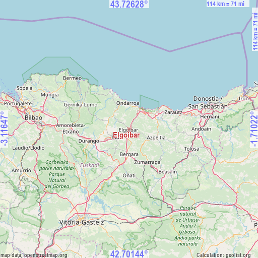
Elgoibar GPS coordinates[2]
43° 12' 57.636" North, 2° 24' 48.024" West
| Map corner | latitude | longitude |
|---|---|---|
| Upper-left | 43.72628°, | -3.11647° |
| Center: | 43.21601°, | -2.41334° |
| Lower-right: | 42.70144°, | -1.71022° |
| Map W x H: | 114×114 km | = 70.8×70.8mi |
| max Lat: | 43.74134° ⇑3.4% North |
| Elgoibar: | 43.21601° |
| min Lat: | ⇓96.6% South 27.64134° |
| min Long | Elgoibar | max Long |
| -18.00367° | -2.41334° | 4.2899° |
| W 62.1%⇐ | ⇒37.9% E |
Elevation
Elevation of Elgoibar is 48 m = 157 ft, and this is 550 m = 1804 ft below average elevation for this country.
| Max E: |
1682 m = 5518 ft | 91.5% |
| Avg. | 598 m = 1962 ft | |
| Elgoibar | 48 m = 157 ft | |
Min E: |
0 m = 0 ft | 8.5% |
See also: Spain elevation on elevation.city.
Geographical zone
Elgoibar is located in North temperate zone (between Tropic of Cancer and the Arctic Circle). Distance of this Northern Tropic circle is 2199.3 km =1366.6 mi to South.| Distance of | km | miles | from Elgoibar |
|---|---|---|---|
| North Pole | 5201.9 | 3232.3 | to North |
| Arctic Circle | 2596 | 1613.1 | to North |
| Tropic Cancer | 2199.3 | 1366.6 | to South |
| Equator | 4805.2 | 2985.8 | to South |


Nearby cities:
15 places around Elgoibar: (largest is in red/bold)
• Azkoitia
9.3 km =5.8 mi,  117°
117°
• Azpeitia
12.4 km =7.7 mi,  107°
107°
• Bergara
11.2 km =7 mi,  181°
181°
• Berriatua
12 km =7.5 mi,  338°
338°
• Deba
10.2 km =6.3 mi,  29°
29°
• Eibar
5.9 km =3.7 mi,  233°
233°
• Elgeta
10.7 km =6.6 mi,  214°
214°
• Ermua
7.9 km =4.9 mi,  246°
246°
• Etxebarria
6.7 km =4.2 mi,  309°
309°
• Markina-Xemein
9 km =5.6 mi, 308°
• Mendaro
4.7 km =2.9 mi, 28°
• Mutriku
10.3 km =6.4 mi,  12°
12°
• Ondarroa
11.2 km =7 mi,  358°
358°
• Zaldibar
11.2 km =7 mi,  240°
240°
• Zestoa
12.9 km =8 mi,  78°
78°
Sources, notices
• [Note1] Compared only with cities in Spain existing in our database
• [Src1] Map data: © OpenStreetMap contributors (CC-BY-SA)
• [Src2] Other city data from geonames.org with taken over terms of usage.
• [Src3] Geographical zone / Annual Mean Temperature by Robert A. Rohde @ Wikipedia
