Azkoitia geodata
Azkoitia (Basque Country) is a seat of a third-order administrative division; located in Spain in Europe/Madrid (GMT+2) time zone. With population of 11,266 people, there are 780 cities with bigger population in this country. Compared to other cities in Spain, 96.2% of cities are located further ↓South; 63.3% of cities are located further ←West and 86.6% of cities have higher elevation than Azkoitia. Note1


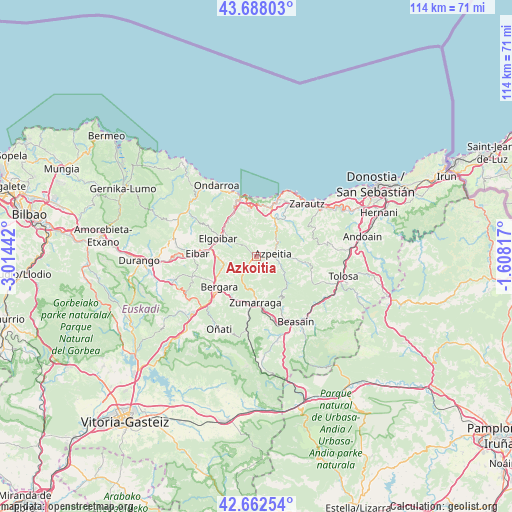
Azkoitia GPS coordinates[2]
43° 10' 38.784" North, 2° 18' 40.644" West
| Map corner | latitude | longitude |
|---|---|---|
| Upper-left | 43.68803°, | -3.01442° |
| Center: | 43.17744°, | -2.31129° |
| Lower-right: | 42.66254°, | -1.60817° |
| Map W x H: | 114×114 km | = 70.8×70.8mi |
| max Lat: | 43.74134° ⇑3.8% North |
| Azkoitia: | 43.17744° |
| min Lat: | ⇓96.2% South 27.64134° |
| min Long | Azkoitia | max Long |
| -18.00367° | -2.31129° | 4.2899° |
| W 63.3%⇐ | ⇒36.7% E |
Elevation
Elevation of Azkoitia is 115 m = 377 ft, and this is 483 m = 1585 ft below average elevation for this country.
| Max E: |
1682 m = 5518 ft | 86.6% |
| Avg. | 598 m = 1962 ft | |
| Azkoitia | 115 m = 377 ft | |
Min E: |
0 m = 0 ft | 13.4% |
See also: Spain elevation on elevation.city.
Geographical zone
Azkoitia is located in North temperate zone (between Tropic of Cancer and the Arctic Circle). Distance of this Northern Tropic circle is 2195 km =1363.9 mi to South.| Distance of | km | miles | from Azkoitia |
|---|---|---|---|
| North Pole | 5206.2 | 3235 | to North |
| Arctic Circle | 2600.3 | 1615.8 | to North |
| Tropic Cancer | 2195 | 1363.9 | to South |
| Equator | 4800.9 | 2983.1 | to South |


Nearby cities:
15 places around Azkoitia: (largest is in red/bold)
• Aizarnazabal
10.6 km =6.6 mi,  34°
34°
• Antzuola
10.5 km =6.5 mi,  212°
212°
• Azpeitia
3.6 km =2.2 mi,  81°
81°
• Beizama
10.2 km =6.3 mi,  118°
118°
• Bergara
11.1 km =6.9 mi,  231°
231°
• Deba
13.6 km =8.5 mi,  345°
345°
• Eibar
13 km =8.1 mi,  273°
273°
• Elgoibar
9.3 km =5.8 mi,  297°
297°
• Errezil
11.2 km =7 mi,  97°
97°
• Legazpi
14 km =8.7 mi,  188°
188°
• Mendaro
10.4 km =6.5 mi,  324°
324°
• Urretxu
9.6 km =6 mi,  182°
182°
• Zestoa
8.2 km =5.1 mi, 31°
• Zumaia
13.9 km =8.6 mi,  19°
19°
• Zumarraga
9.9 km =6.2 mi, 181°
Sources, notices
• [Note1] Compared only with cities in Spain existing in our database
• [Src1] Map data: © OpenStreetMap contributors (CC-BY-SA)
• [Src2] Other city data from geonames.org with taken over terms of usage.
• [Src3] Geographical zone / Annual Mean Temperature by Robert A. Rohde @ Wikipedia
