Bergara geodata
Bergara (Basque Country) is a populated place; located in Spain in Europe/Madrid (GMT+2) time zone. With population of 14,707 people, there are 630 cities with bigger population in this country. Compared to other cities in Spain, 95.4% of cities are located further ↓South; 62% of cities are located further ←West and 83.9% of cities have higher elevation than Bergara. Note1


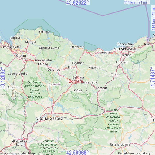
Bergara GPS coordinates[2]
43° 6' 54.36" North, 2° 25' 3" West
| Map corner | latitude | longitude |
|---|---|---|
| Upper-left | 43.62622°, | -3.12062° |
| Center: | 43.1151°, | -2.4175° |
| Lower-right: | 42.59968°, | -1.71437° |
| Map W x H: | 114.1×114.1 km | = 70.9×70.9mi |
| max Lat: | 43.74134° ⇑4.6% North |
| Bergara: | 43.1151° |
| min Lat: | ⇓95.4% South 27.64134° |
| min Long | Bergara | max Long |
| -18.00367° | -2.4175° | 4.2899° |
| W 62%⇐ | ⇒38% E |
Elevation
Elevation of Bergara is 157 m = 515 ft, and this is 441 m = 1447 ft below average elevation for this country.
| Max E: |
1682 m = 5518 ft | 83.9% |
| Avg. | 598 m = 1962 ft | |
| Bergara | 157 m = 515 ft | |
Min E: |
0 m = 0 ft | 16.1% |
See also: Spain elevation on elevation.city.
Geographical zone
Bergara is located in North temperate zone (between Tropic of Cancer and the Arctic Circle). Distance of this Northern Tropic circle is 2188 km =1359.6 mi to South.| Distance of | km | miles | from Bergara |
|---|---|---|---|
| North Pole | 5213.1 | 3239.3 | to North |
| Arctic Circle | 2607.2 | 1620 | to North |
| Tropic Cancer | 2188 | 1359.6 | to South |
| Equator | 4793.9 | 2978.8 | to South |


Nearby cities:
15 places around Bergara: (largest is in red/bold)
• Antzuola
3.6 km =2.2 mi,  123°
123°
• Aretxabaleta
11.4 km =7.1 mi,  218°
218°
• Arrasate / Mondragón
8.1 km =5 mi,  226°
226°
• Azkoitia
11.1 km =6.9 mi,  51°
51°
• Eibar
8.9 km =5.5 mi,  330°
330°
• Elgeta
6.3 km =3.9 mi,  292°
292°
• Elgoibar
11.2 km =7 mi,  1°
1°
• Elorrio
10.1 km =6.3 mi,  278°
278°
• Ermua
10.6 km =6.6 mi,  319°
319°
• Gabiria
13.4 km =8.3 mi, 123°
• Legazpi
9.5 km =5.9 mi,  136°
136°
• Oñati
9.2 km =5.7 mi,  176°
176°
• Urretxu
8.6 km =5.3 mi,  108°
108°
• Zaldibar
11 km =6.8 mi,  301°
301°
• Zumarraga
8.9 km =5.5 mi, 109°
Sources, notices
• [Note1] Compared only with cities in Spain existing in our database
• [Src1] Map data: © OpenStreetMap contributors (CC-BY-SA)
• [Src2] Other city data from geonames.org with taken over terms of usage.
• [Src3] Geographical zone / Annual Mean Temperature by Robert A. Rohde @ Wikipedia
