Elantxobe geodata
Elantxobe (Basque Country) is a seat of a third-order administrative division; located in Spain in Europe/Madrid (GMT+2) time zone. In our database, there are 6762 cities with bigger population. Compared to other cities in Spain, 98.9% of cities are located further ↓South; 59.4% of cities are located further ←West and 89.2% of cities have higher elevation than Elantxobe. Note1


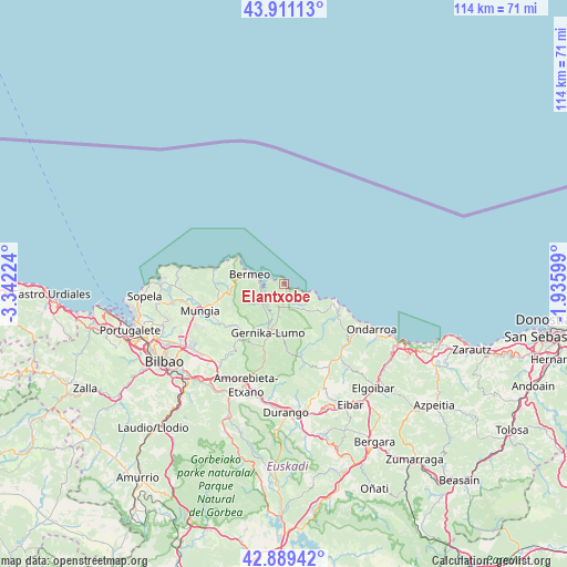
Elantxobe GPS coordinates[2]
43° 24' 8.748" North, 2° 38' 20.832" West
| Map corner | latitude | longitude |
|---|---|---|
| Upper-left | 43.91113°, | -3.34224° |
| Center: | 43.40243°, | -2.63912° |
| Lower-right: | 42.88942°, | -1.93599° |
| Map W x H: | 113.6×113.6 km | = 70.6×70.6mi |
| max Lat: | 43.74134° ⇑1.1% North |
| Elantxobe: | 43.40243° |
| min Lat: | ⇓98.9% South 27.64134° |
| min Long | Elantxobe | max Long |
| -18.00367° | -2.63912° | 4.2899° |
| W 59.4%⇐ | ⇒40.6% E |
Elevation
Elevation of Elantxobe is 77 m = 253 ft, and this is 521 m = 1709 ft below average elevation for this country.
| Max E: |
1682 m = 5518 ft | 89.2% |
| Avg. | 598 m = 1962 ft | |
| Elantxobe | 77 m = 253 ft | |
Min E: |
0 m = 0 ft | 10.8% |
See also: Spain elevation on elevation.city.
Geographical zone
Elantxobe is located in North temperate zone (between Tropic of Cancer and the Arctic Circle). Distance of this Northern Tropic circle is 2220 km =1379.4 mi to South.| Distance of | km | miles | from Elantxobe |
|---|---|---|---|
| North Pole | 5181.2 | 3219.4 | to North |
| Arctic Circle | 2575.3 | 1600.2 | to North |
| Tropic Cancer | 2220 | 1379.4 | to South |
| Equator | 4825.9 | 2998.7 | to South |


Nearby cities:
15 places around Elantxobe: (largest is in red/bold)
• Amoroto
13.2 km =8.2 mi,  129°
129°
• Aulesti
12.8 km =8 mi,  152°
152°
• Axpe de Busturia
5.2 km =3.2 mi,  246°
246°
• Bermeo
7 km =4.3 mi,  287°
287°
• Ea
5 km =3.1 mi,  120°
120°
• Errigoiti
11.4 km =7.1 mi,  213°
213°
• Forua
8.2 km =5.1 mi,  200°
200°
• Gernika-Lumo
10.2 km =6.3 mi, 200°
• Ibarrangelu
1.4 km =0.9 mi,  163°
163°
• Ispaster
9.4 km =5.8 mi,  114°
114°
• Kortezubi
7.7 km =4.8 mi,  186°
186°
• Lekeitio
11.6 km =7.2 mi, 111°
• Mendexa
14 km =8.7 mi, 116°
• Mundaka
4.8 km =3 mi,  277°
277°
• Muxika
13.2 km =8.2 mi, 197°
Sources, notices
• [Note1] Compared only with cities in Spain existing in our database
• [Src1] Map data: © OpenStreetMap contributors (CC-BY-SA)
• [Src2] Other city data from geonames.org with taken over terms of usage.
• [Src3] Geographical zone / Annual Mean Temperature by Robert A. Rohde @ Wikipedia
