Kortezubi geodata
Kortezubi (Basque Country) is a seat of a third-order administrative division; located in Spain in Europe/Madrid (GMT+2) time zone. In our database, there are 6762 cities with bigger population. Compared to other cities in Spain, 98% of cities are located further ↓South; 59.2% of cities are located further ←West and 98.2% of cities have higher elevation than Kortezubi. Note1


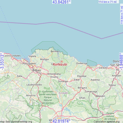
Kortezubi GPS coordinates[2]
43° 19' 59.988" North, 2° 39' 0" West
| Map corner | latitude | longitude |
|---|---|---|
| Upper-left | 43.84261°, | -3.35313° |
| Center: | 43.33333°, | -2.65° |
| Lower-right: | 42.81974°, | -1.94688° |
| Map W x H: | 113.7×113.7 km | = 70.6×70.6mi |
| max Lat: | 43.74134° ⇑2% North |
| Kortezubi: | 43.33333° |
| min Lat: | ⇓98% South 27.64134° |
| min Long | Kortezubi | max Long |
| -18.00367° | -2.65° | 4.2899° |
| W 59.2%⇐ | ⇒40.8% E |
Elevation
Elevation of Kortezubi is 11 m = 36 ft, and this is 587 m = 1926 ft below average elevation for this country.
| Max E: |
1682 m = 5518 ft | 98.2% |
| Avg. | 598 m = 1962 ft | |
| Kortezubi | 11 m = 36 ft | |
Min E: |
0 m = 0 ft | 1.8% |
See also: Spain elevation on elevation.city.
Geographical zone
Kortezubi is located in North temperate zone (between Tropic of Cancer and the Arctic Circle). Distance of this Northern Tropic circle is 2212.3 km =1374.7 mi to South.| Distance of | km | miles | from Kortezubi |
|---|---|---|---|
| North Pole | 5188.8 | 3224.2 | to North |
| Arctic Circle | 2583 | 1605 | to North |
| Tropic Cancer | 2212.3 | 1374.7 | to South |
| Equator | 4818.2 | 2993.9 | to South |


Nearby cities:
15 places around Kortezubi: (largest is in red/bold)
• Amoroto
11.1 km =6.9 mi,  94°
94°
• Aulesti
7.7 km =4.8 mi,  118°
118°
• Axpe de Busturia
6.8 km =4.2 mi,  325°
325°
• Bermeo
11.3 km =7 mi, 329°
• Ea
7.3 km =4.5 mi,  45°
45°
• Elantxobe
7.7 km =4.8 mi,  6°
6°
• Errigoiti
5.7 km =3.5 mi,  251°
251°
• Forua
2 km =1.2 mi,  270°
270°
• Gernika-Lumo
3.3 km =2.1 mi,  235°
235°
• Ibarrangelu
6.5 km =4 mi, 11°
• Ispaster
10.1 km =6.3 mi,  68°
68°
• Lekeitio
12.2 km =7.6 mi, 73°
• Mendexa
13.5 km =8.4 mi,  84°
84°
• Mundaka
9.2 km =5.7 mi, 334°
• Muxika
5.9 km =3.7 mi,  212°
212°
Sources, notices
• [Note1] Compared only with cities in Spain existing in our database
• [Src1] Map data: © OpenStreetMap contributors (CC-BY-SA)
• [Src2] Other city data from geonames.org with taken over terms of usage.
• [Src3] Geographical zone / Annual Mean Temperature by Robert A. Rohde @ Wikipedia
