Cuacos geodata
Cuacos (Extremadura) is a populated place; located in Spain in Europe/Madrid (GMT+2) time zone. With population of 965 people, there are 2992 cities with bigger population in this country. Compared to other cities in Spain, 68.7% of cities are located further ↑North; 82.1% of cities are located further →East and 59.6% of cities have higher elevation than Cuacos. Note1
Administrative division(s):
- Level 1: Extremadura
- Level 2: Provincia de Cáceres
- Level 3: Cuacos de Yuste


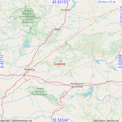
Cuacos GPS coordinates[2]
40° 6' 19.296" North, 5° 43' 26.364" West
| Map corner | latitude | longitude |
|---|---|---|
| Upper-left | 40.64103°, | -6.42711° |
| Center: | 40.10536°, | -5.72399° |
| Lower-right: | 39.56544°, | -5.02086° |
| Map W x H: | 119.6×119.6 km | = 74.3×74.3mi |
| max Lat: | 43.74134° ⇑68.7% North |
| Cuacos: | 40.10536° |
| min Lat: | ⇓31.3% South 27.64134° |
| min Long | Cuacos | max Long |
| -18.00367° | -5.72399° | 4.2899° |
| W 17.9%⇐ | ⇒82.1% E |
Elevation
Elevation of Cuacos is 532 m = 1745 ft, and this is 66 m = 217 ft below average elevation for this country.
| Max E: |
1682 m = 5518 ft | 59.6% |
| Avg. | 598 m = 1962 ft | |
| Cuacos | 532 m = 1745 ft | |
Min E: |
0 m = 0 ft | 40.4% |
See also: Spain elevation on elevation.city.
Geographical zone
Cuacos is located in North temperate zone (between Tropic of Cancer and the Arctic Circle). Distance of this Northern Tropic circle is 1853.4 km =1151.6 mi to South.| Distance of | km | miles | from Cuacos |
|---|---|---|---|
| North Pole | 5547.8 | 3447.2 | to North |
| Arctic Circle | 2941.9 | 1828 | to North |
| Tropic Cancer | 1853.4 | 1151.6 | to South |
| Equator | 4459.3 | 2770.9 | to South |


Nearby cities:
15 places around Cuacos: (largest is in red/bold)
• Aldeanueva de la Vera
3.1 km =1.9 mi,  38°
38°
• Arroyomolinos de la Vera
12.3 km =7.6 mi,  241°
241°
• Barrado
13.5 km =8.4 mi,  260°
260°
• Cabezuela del Valle
12.1 km =7.5 mi,  324°
324°
• Collado
5.4 km =3.4 mi,  176°
176°
• Garganta la Olla
4.5 km =2.8 mi,  277°
277°
• Guijo de Santa Bárbara
8 km =5 mi,  47°
47°
• Jarandilla de la Vera
6 km =3.7 mi,  63°
63°
• Jaraíz de la Vera
5.7 km =3.5 mi,  207°
207°
• Jerte
13.2 km =8.2 mi,  350°
350°
• Losar de la Vera
10.3 km =6.4 mi,  79°
79°
• Navaconcejo
12.1 km =7.5 mi,  311°
311°
• Piornal
10.6 km =6.6 mi, 277°
• Robledillo de la Vera
11.5 km =7.1 mi,  92°
92°
• Torremenga
7.8 km =4.8 mi, 213°
Sources, notices
• [Note1] Compared only with cities in Spain existing in our database
• [Src1] Map data: © OpenStreetMap contributors (CC-BY-SA)
• [Src2] Other city data from geonames.org with taken over terms of usage.
• [Src3] Geographical zone / Annual Mean Temperature by Robert A. Rohde @ Wikipedia
