Jerte geodata
Jerte (Extremadura) is a seat of a third-order administrative division; located in Spain in Europe/Madrid (GMT+2) time zone. With population of 1,312 people, there are 2630 cities with bigger population in this country. Compared to other cities in Spain, 66.9% of cities are located further ↑North; 82.6% of cities are located further →East and 54% of cities have higher elevation than Jerte. Note1


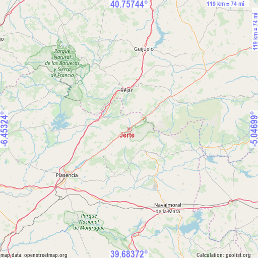
Jerte GPS coordinates[2]
40° 13' 21.756" North, 5° 45' 0.396" West
| Map corner | latitude | longitude |
|---|---|---|
| Upper-left | 40.75744°, | -6.45324° |
| Center: | 40.22271°, | -5.75011° |
| Lower-right: | 39.68372°, | -5.04699° |
| Map W x H: | 119.4×119.4 km | = 74.2×74.2mi |
| max Lat: | 43.74134° ⇑66.9% North |
| Jerte: | 40.22271° |
| min Lat: | ⇓33.1% South 27.64134° |
| min Long | Jerte | max Long |
| -18.00367° | -5.75011° | 4.2899° |
| W 17.4%⇐ | ⇒82.6% E |
Elevation
Elevation of Jerte is 612 m = 2008 ft, and this is 14 m = 46 ft above average elevation for this country.
| Max E: |
1682 m = 5518 ft | 54% |
| Jerte | 612 m 2008 ft | |
| Avg. | 598 m = 1962 ft | |
Min E: |
0 m = 0 ft | 46% |
See also: Spain elevation on elevation.city.
Geographical zone
Jerte is located in North temperate zone (between Tropic of Cancer and the Arctic Circle). Distance of this Northern Tropic circle is 1866.4 km =1159.7 mi to South.| Distance of | km | miles | from Jerte |
|---|---|---|---|
| North Pole | 5534.7 | 3439.1 | to North |
| Arctic Circle | 2928.8 | 1819.9 | to North |
| Tropic Cancer | 1866.4 | 1159.7 | to South |
| Equator | 4472.3 | 2779 | to South |


Nearby cities:
15 places around Jerte: (largest is in red/bold)
• Aldeanueva de la Vera
11.4 km =7.1 mi,  158°
158°
• Baños de Montemayor
14 km =8.7 mi,  318°
318°
• Cabezuela del Valle
5.8 km =3.6 mi,  235°
235°
• Cuacos
13.2 km =8.2 mi,  170°
170°
• Garganta la Olla
12.7 km =7.9 mi,  190°
190°
• Gargantilla
14.8 km =9.2 mi,  281°
281°
• Guijo de Santa Bárbara
11.2 km =7 mi,  133°
133°
• Hervás
11.3 km =7 mi,  298°
298°
• Jarandilla de la Vera
12.9 km =8 mi,  143°
143°
• La Garganta
13.3 km =8.3 mi,  332°
332°
• Navaconcejo
8.5 km =5.3 mi,  233°
233°
• Piornal
14.4 km =8.9 mi,  215°
215°
• Puerto Castilla
13 km =8.1 mi,  55°
55°
• Tornavacas
6.3 km =3.9 mi, 55°
• Valdastillas
14.8 km =9.2 mi, 227°
Sources, notices
• [Note1] Compared only with cities in Spain existing in our database
• [Src1] Map data: © OpenStreetMap contributors (CC-BY-SA)
• [Src2] Other city data from geonames.org with taken over terms of usage.
• [Src3] Geographical zone / Annual Mean Temperature by Robert A. Rohde @ Wikipedia
