Piornal geodata
Piornal (Extremadura) is a seat of a third-order administrative division; located in Spain in Europe/Madrid (GMT+2) time zone. With population of 1,528 people, there are 2444 cities with bigger population in this country. Compared to other cities in Spain, 68.4% of cities are located further ↑North; 83.9% of cities are located further →East and 96.3% of cities have lower elevation than Piornal. Note1


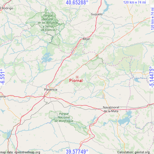
Piornal GPS coordinates[2]
40° 7' 2.316" North, 5° 50' 52.332" West
| Map corner | latitude | longitude |
|---|---|---|
| Upper-left | 40.65288°, | -6.551° |
| Center: | 40.11731°, | -5.84787° |
| Lower-right: | 39.57749°, | -5.14475° |
| Map W x H: | 119.6×119.6 km | = 74.3×74.3mi |
| max Lat: | 43.74134° ⇑68.4% North |
| Piornal: | 40.11731° |
| min Lat: | ⇓31.6% South 27.64134° |
| min Long | Piornal | max Long |
| -18.00367° | -5.84787° | 4.2899° |
| W 16.1%⇐ | ⇒83.9% E |
Elevation
Elevation of Piornal is 1181 m = 3875 ft, and this is 583 m = 1913 ft above average elevation for this country.
| Max E: |
1682 m = 5518 ft | 3.7% |
| Piornal | 1181 m 3875 ft | |
| Avg. | 598 m = 1962 ft | |
Min E: |
0 m = 0 ft | 96.3% |
See also: Spain elevation on elevation.city.
Geographical zone
Piornal is located in North temperate zone (between Tropic of Cancer and the Arctic Circle). Distance of this Northern Tropic circle is 1854.7 km =1152.5 mi to South.| Distance of | km | miles | from Piornal |
|---|---|---|---|
| North Pole | 5546.4 | 3446.4 | to North |
| Arctic Circle | 2940.5 | 1827.1 | to North |
| Tropic Cancer | 1854.7 | 1152.5 | to South |
| Equator | 4460.6 | 2771.7 | to South |


Nearby cities:
15 places around Piornal: (largest is in red/bold)
• Aldeanueva de la Vera
12.5 km =7.8 mi,  85°
85°
• Arroyomolinos de la Vera
7.2 km =4.5 mi,  182°
182°
• Barrado
4.6 km =2.9 mi,  217°
217°
• Cabezuela del Valle
9.2 km =5.7 mi,  22°
22°
• Cabrero
3.9 km =2.4 mi,  263°
263°
• Casas del Castañar
5 km =3.1 mi, 257°
• Cuacos
10.6 km =6.6 mi,  97°
97°
• El Torno
8.5 km =5.3 mi,  284°
284°
• Garganta la Olla
6.1 km =3.8 mi, 97°
• Gargüera
9.2 km =5.7 mi,  227°
227°
• Jaraíz de la Vera
10.2 km =6.3 mi,  128°
128°
• Navaconcejo
6.8 km =4.2 mi,  12°
12°
• Tejeda de Tiétar
11.2 km =7 mi,  189°
189°
• Torremenga
10 km =6.2 mi,  141°
141°
• Valdastillas
3.2 km =2 mi,  303°
303°
Sources, notices
• [Note1] Compared only with cities in Spain existing in our database
• [Src1] Map data: © OpenStreetMap contributors (CC-BY-SA)
• [Src2] Other city data from geonames.org with taken over terms of usage.
• [Src3] Geographical zone / Annual Mean Temperature by Robert A. Rohde @ Wikipedia
