Crémenes geodata
Crémenes (Castille and León) is a seat of a third-order administrative division; located in Spain in Europe/Madrid (GMT+2) time zone. With population of 867 people, there are 3109 cities with bigger population in this country. Compared to other cities in Spain, 93.6% of cities are located further ↓South; 74.3% of cities are located further →East and 87.9% of cities have lower elevation than Crémenes. Note1


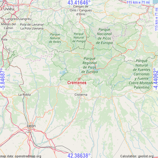
Crémenes GPS coordinates[2]
42° 54' 12.852" North, 5° 8' 37.464" West
| Map corner | latitude | longitude |
|---|---|---|
| Upper-left | 43.41646°, | -5.84687° |
| Center: | 42.90357°, | -5.14374° |
| Lower-right: | 42.38638°, | -4.44062° |
| Map W x H: | 114.5×114.5 km | = 71.1×71.1mi |
| max Lat: | 43.74134° ⇑6.4% North |
| Crémenes: | 42.90357° |
| min Lat: | ⇓93.6% South 27.64134° |
| min Long | Crémenes | max Long |
| -18.00367° | -5.14374° | 4.2899° |
| W 25.7%⇐ | ⇒74.3% E |
Elevation
Elevation of Crémenes is 995 m = 3264 ft, and this is 397 m = 1302 ft above average elevation for this country.
| Max E: |
1682 m = 5518 ft | 12.1% |
| Crémenes | 995 m 3264 ft | |
| Avg. | 598 m = 1962 ft | |
Min E: |
0 m = 0 ft | 87.9% |
See also: Spain elevation on elevation.city.
Geographical zone
Crémenes is located in North temperate zone (between Tropic of Cancer and the Arctic Circle). Distance of this Northern Tropic circle is 2164.5 km =1345 mi to South.| Distance of | km | miles | from Crémenes |
|---|---|---|---|
| North Pole | 5236.6 | 3253.9 | to North |
| Arctic Circle | 2630.7 | 1634.6 | to North |
| Tropic Cancer | 2164.5 | 1345 | to South |
| Equator | 4770.4 | 2964.2 | to South |


Nearby cities:
15 places around Crémenes: (largest is in red/bold)
• Acebedo
15.3 km =9.5 mi,  8°
8°
• Boca de Huérgano
19.5 km =12.1 mi,  66°
66°
• Boñar
15.2 km =9.4 mi,  254°
254°
• Burón
15.4 km =9.6 mi,  29°
29°
• Cistierna
11.2 km =7 mi,  172°
172°
• La Ercina
11.7 km =7.3 mi,  211°
211°
• Maraña
16.5 km =10.3 mi,  350°
350°
• Prado de la Guzpeña
16.5 km =10.3 mi,  144°
144°
• Prioro
14.7 km =9.1 mi,  93°
93°
• Puebla de Lillo
15.6 km =9.7 mi,  317°
317°
• Reyero
6.7 km =4.2 mi, 318°
• Riaño
14 km =8.7 mi,  54°
54°
• Sabero
7.5 km =4.7 mi,  183°
183°
• Valderrueda
18.8 km =11.7 mi,  121°
121°
• Vegaquemada
18 km =11.2 mi,  238°
238°
Sources, notices
• [Note1] Compared only with cities in Spain existing in our database
• [Src1] Map data: © OpenStreetMap contributors (CC-BY-SA)
• [Src2] Other city data from geonames.org with taken over terms of usage.
• [Src3] Geographical zone / Annual Mean Temperature by Robert A. Rohde @ Wikipedia
