Vegaquemada geodata
Vegaquemada (Castille and León) is a seat of a third-order administrative division; located in Spain in Europe/Madrid (GMT+2) time zone. With population of 477 people, there are 3940 cities with bigger population in this country. Compared to other cities in Spain, 92.9% of cities are located further ↓South; 76.7% of cities are located further →East and 83.8% of cities have lower elevation than Vegaquemada. Note1
Administrative division(s):
- Level 1: Castille and León
- Level 2: Provincia de León
- Level 3: Vegaquemada


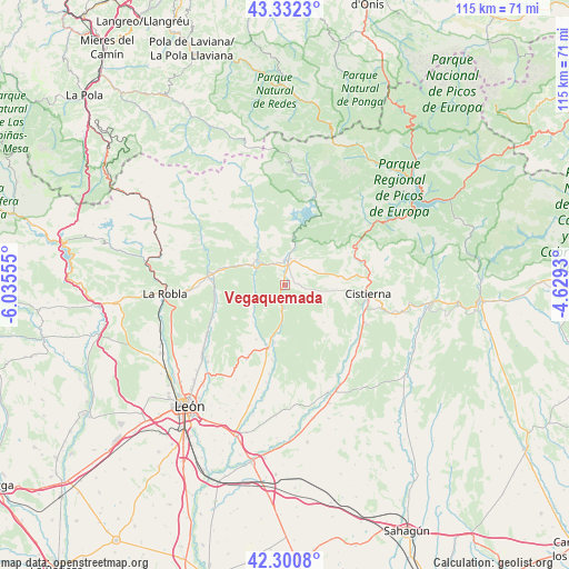
Vegaquemada GPS coordinates[2]
42° 49' 7.32" North, 5° 19' 56.712" West
| Map corner | latitude | longitude |
|---|---|---|
| Upper-left | 43.3323°, | -6.03555° |
| Center: | 42.8187°, | -5.33242° |
| Lower-right: | 42.3008°, | -4.6293° |
| Map W x H: | 114.7×114.7 km | = 71.3×71.3mi |
| max Lat: | 43.74134° ⇑7.1% North |
| Vegaquemada: | 42.8187° |
| min Lat: | ⇓92.9% South 27.64134° |
| min Long | Vegaquemada | max Long |
| -18.00367° | -5.33242° | 4.2899° |
| W 23.3%⇐ | ⇒76.7% E |
Elevation
Elevation of Vegaquemada is 938 m = 3077 ft, and this is 340 m = 1115 ft above average elevation for this country.
| Max E: |
1682 m = 5518 ft | 16.2% |
| Vegaquemada | 938 m 3077 ft | |
| Avg. | 598 m = 1962 ft | |
Min E: |
0 m = 0 ft | 83.8% |
See also: Spain elevation on elevation.city.
Geographical zone
Vegaquemada is located in North temperate zone (between Tropic of Cancer and the Arctic Circle). Distance of this Northern Tropic circle is 2155.1 km =1339.1 mi to South.| Distance of | km | miles | from Vegaquemada |
|---|---|---|---|
| North Pole | 5246.1 | 3259.8 | to North |
| Arctic Circle | 2640.2 | 1640.5 | to North |
| Tropic Cancer | 2155.1 | 1339.1 | to South |
| Equator | 4761 | 2958.3 | to South |


Nearby cities:
15 places around Vegaquemada: (largest is in red/bold)
• Boñar
5.4 km =3.4 mi,  7°
7°
• Cistierna
16.9 km =10.5 mi,  95°
95°
• Crémenes
18 km =11.2 mi,  58°
58°
• Cubillas de Rueda
22.2 km =13.8 mi,  144°
144°
• Garrafe de Torío
18.3 km =11.4 mi,  238°
238°
• Gradefes
23.3 km =14.5 mi,  158°
158°
• La Ercina
9.3 km =5.8 mi,  93°
93°
• La Robla
24.3 km =15.1 mi,  265°
265°
• Matallana de Torío
16.2 km =10.1 mi,  288°
288°
• Puebla de Lillo
21.5 km =13.4 mi, 12°
• Reyero
18.1 km =11.2 mi,  36°
36°
• Sabero
15.1 km =9.4 mi,  82°
82°
• Santa Colomba de Curueño
10 km =6.2 mi,  220°
220°
• Valdepiélago
7.7 km =4.8 mi,  316°
316°
• Vegacervera
18.3 km =11.4 mi, 294°
Sources, notices
• [Note1] Compared only with cities in Spain existing in our database
• [Src1] Map data: © OpenStreetMap contributors (CC-BY-SA)
• [Src2] Other city data from geonames.org with taken over terms of usage.
• [Src3] Geographical zone / Annual Mean Temperature by Robert A. Rohde @ Wikipedia
