Boñar geodata
Boñar (Castille and León) is a seat of a third-order administrative division; located in Spain in Europe/Madrid (GMT+2) time zone. With population of 2,299 people, there are 2000 cities with bigger population in this country. Compared to other cities in Spain, 93.3% of cities are located further ↓South; 76.6% of cities are located further →East and 86.6% of cities have lower elevation than Boñar. Note1


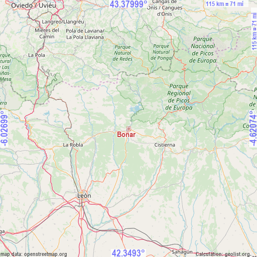
Boñar GPS coordinates[2]
42° 52' 0.48" North, 5° 19' 25.896" West
| Map corner | latitude | longitude |
|---|---|---|
| Upper-left | 43.37999°, | -6.02699° |
| Center: | 42.8668°, | -5.32386° |
| Lower-right: | 42.3493°, | -4.62074° |
| Map W x H: | 114.6×114.6 km | = 71.2×71.2mi |
| max Lat: | 43.74134° ⇑6.7% North |
| Boñar: | 42.8668° |
| min Lat: | ⇓93.3% South 27.64134° |
| min Long | Boñar | max Long |
| -18.00367° | -5.32386° | 4.2899° |
| W 23.4%⇐ | ⇒76.6% E |
Elevation
Elevation of Boñar is 975 m = 3199 ft, and this is 377 m = 1237 ft above average elevation for this country.
| Max E: |
1682 m = 5518 ft | 13.4% |
| Boñar | 975 m 3199 ft | |
| Avg. | 598 m = 1962 ft | |
Min E: |
0 m = 0 ft | 86.6% |
See also: Spain elevation on elevation.city.
Geographical zone
Boñar is located in North temperate zone (between Tropic of Cancer and the Arctic Circle). Distance of this Northern Tropic circle is 2160.4 km =1342.4 mi to South.| Distance of | km | miles | from Boñar |
|---|---|---|---|
| North Pole | 5240.7 | 3256.4 | to North |
| Arctic Circle | 2634.8 | 1637.2 | to North |
| Tropic Cancer | 2160.4 | 1342.4 | to South |
| Equator | 4766.3 | 2961.6 | to South |


Nearby cities:
15 places around Boñar: (largest is in red/bold)
• Acebedo
25.6 km =15.9 mi,  41°
41°
• Cistierna
17.6 km =10.9 mi,  113°
113°
• Crémenes
15.2 km =9.4 mi,  74°
74°
• Cármenes
22.7 km =14.1 mi,  296°
296°
• Garrafe de Torío
22.1 km =13.7 mi,  227°
227°
• La Ercina
10.4 km =6.5 mi,  124°
124°
• Maraña
23.6 km =14.7 mi,  30°
30°
• Matallana de Torío
16 km =9.9 mi,  269°
269°
• Puebla de Lillo
16.1 km =10 mi,  14°
14°
• Reyero
13.7 km =8.5 mi,  48°
48°
• Sabero
14.7 km =9.1 mi,  103°
103°
• Santa Colomba de Curueño
14.8 km =9.2 mi,  209°
209°
• Valdepiélago
6 km =3.7 mi, 272°
• Vegacervera
17.4 km =10.8 mi,  277°
277°
• Vegaquemada
5.4 km =3.4 mi,  187°
187°
Sources, notices
• [Note1] Compared only with cities in Spain existing in our database
• [Src1] Map data: © OpenStreetMap contributors (CC-BY-SA)
• [Src2] Other city data from geonames.org with taken over terms of usage.
• [Src3] Geographical zone / Annual Mean Temperature by Robert A. Rohde @ Wikipedia
