Corbalán geodata
Corbalán (Aragon) is a seat of a third-order administrative division; located in Spain in Europe/Madrid (GMT+2) time zone. With population of 86 people, there are 6079 cities with bigger population in this country. Compared to other cities in Spain, 63.9% of cities are located further ↑North; 77.4% of cities are located further ←West and 98.2% of cities have lower elevation than Corbalán. Note1


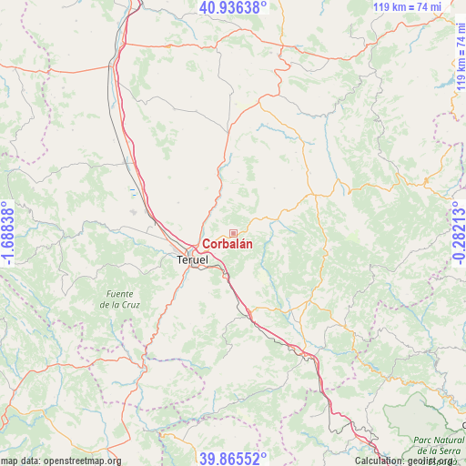
Corbalán GPS coordinates[2]
40° 24' 11.088" North, 0° 59' 6.9" West
| Map corner | latitude | longitude |
|---|---|---|
| Upper-left | 40.93638°, | -1.68838° |
| Center: | 40.40308°, | -0.98525° |
| Lower-right: | 39.86552°, | -0.28213° |
| Map W x H: | 119.1×119.1 km | = 74×74mi |
| max Lat: | 43.74134° ⇑63.9% North |
| Corbalán: | 40.40308° |
| min Lat: | ⇓36.1% South 27.64134° |
| min Long | Corbalán | max Long |
| -18.00367° | -0.98525° | 4.2899° |
| W 77.4%⇐ | ⇒22.6% E |
Elevation
Elevation of Corbalán is 1267 m = 4157 ft, and this is 669 m = 2195 ft above average elevation for this country.
| Max E: |
1682 m = 5518 ft | 1.8% |
| Corbalán | 1267 m 4157 ft | |
| Avg. | 598 m = 1962 ft | |
Min E: |
0 m = 0 ft | 98.2% |
See also: Spain elevation on elevation.city.
Geographical zone
Corbalán is located in North temperate zone (between Tropic of Cancer and the Arctic Circle). Distance of this Northern Tropic circle is 1886.5 km =1172.2 mi to South.| Distance of | km | miles | from Corbalán |
|---|---|---|---|
| North Pole | 5514.7 | 3426.7 | to North |
| Arctic Circle | 2908.8 | 1807.4 | to North |
| Tropic Cancer | 1886.5 | 1172.2 | to South |
| Equator | 4492.4 | 2791.4 | to South |


Nearby cities:
15 places around Corbalán: (largest is in red/bold)
• Ababuj
22.1 km =13.7 mi,  42°
42°
• Alcalá de la Selva
22.7 km =14.1 mi,  98°
98°
• Alfambra
16.4 km =10.2 mi,  345°
345°
• Cabra de Mora
17.9 km =11.1 mi,  122°
122°
• Cedrillas
11.9 km =7.4 mi,  71°
71°
• Cuevas Labradas
7.8 km =4.8 mi,  315°
315°
• El Castellar
14.8 km =9.2 mi,  106°
106°
• Escorihuela
15.7 km =9.8 mi,  4°
4°
• Formiche Alto
11.8 km =7.3 mi,  138°
138°
• La Puebla de Valverde
20.5 km =12.7 mi,  166°
166°
• Monteagudo del Castillo
15.4 km =9.6 mi, 67°
• Orrios
20.7 km =12.9 mi,  359°
359°
• Peralejos
9.9 km =6.2 mi,  335°
335°
• Teruel
12.1 km =7.5 mi,  238°
238°
• Villastar
19.6 km =12.2 mi,  226°
226°
Sources, notices
• [Note1] Compared only with cities in Spain existing in our database
• [Src1] Map data: © OpenStreetMap contributors (CC-BY-SA)
• [Src2] Other city data from geonames.org with taken over terms of usage.
• [Src3] Geographical zone / Annual Mean Temperature by Robert A. Rohde @ Wikipedia
