Teruel geodata
Teruel (Aragon) is a seat of a second-order administrative division; located in Spain in Europe/Madrid (GMT+2) time zone. With population of 35,396 people, there are 252 cities with bigger population in this country. Compared to other cities in Spain, 65% of cities are located further ↑North; 76.2% of cities are located further ←West and 81.1% of cities have lower elevation than Teruel. Note1


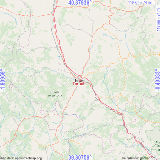
Teruel GPS coordinates[2]
40° 20' 44.16" North, 1° 6' 23.256" West
| Map corner | latitude | longitude |
|---|---|---|
| Upper-left | 40.87936°, | -1.80959° |
| Center: | 40.3456°, | -1.10646° |
| Lower-right: | 39.80758°, | -0.40333° |
| Map W x H: | 119.2×119.2 km | = 74.1×74.1mi |
| max Lat: | 43.74134° ⇑65% North |
| Teruel: | 40.3456° |
| min Lat: | ⇓35% South 27.64134° |
| min Long | Teruel | max Long |
| -18.00367° | -1.10646° | 4.2899° |
| W 76.2%⇐ | ⇒23.8% E |
Elevation
Elevation of Teruel is 908 m = 2979 ft, and this is 310 m = 1017 ft above average elevation for this country.
| Max E: |
1682 m = 5518 ft | 18.9% |
| Teruel | 908 m 2979 ft | |
| Avg. | 598 m = 1962 ft | |
Min E: |
0 m = 0 ft | 81.1% |
See also: Spain elevation on elevation.city.
Geographical zone
Teruel is located in North temperate zone (between Tropic of Cancer and the Arctic Circle). Distance of this Northern Tropic circle is 1880.1 km =1168.2 mi to South.| Distance of | km | miles | from Teruel |
|---|---|---|---|
| North Pole | 5521.1 | 3430.7 | to North |
| Arctic Circle | 2915.2 | 1811.4 | to North |
| Tropic Cancer | 1880.1 | 1168.2 | to South |
| Equator | 4486 | 2787.5 | to South |


Nearby cities:
15 places around Teruel: (largest is in red/bold)
• Bezas
18.6 km =11.6 mi,  264°
264°
• Cascante del Río
16.6 km =10.3 mi,  182°
182°
• Cella
19.4 km =12.1 mi,  307°
307°
• Corbalán
12.1 km =7.5 mi,  58°
58°
• Cubla
15.3 km =9.5 mi,  171°
171°
• Cuevas Labradas
12.9 km =8 mi,  21°
21°
• Formiche Alto
18.3 km =11.4 mi,  97°
97°
• Gea de Albarracín
21.7 km =13.5 mi,  289°
289°
• La Puebla de Valverde
20.3 km =12.6 mi,  131°
131°
• Peralejos
16.6 km =10.3 mi, 21°
• Rubiales
16 km =9.9 mi,  241°
241°
• Tramacastiel
20.9 km =13 mi,  213°
213°
• Valacloche
17.2 km =10.7 mi, 175°
• Villastar
8.1 km =5 mi, 207°
• Villel
14.1 km =8.8 mi, 208°
Sources, notices
• [Note1] Compared only with cities in Spain existing in our database
• [Src1] Map data: © OpenStreetMap contributors (CC-BY-SA)
• [Src2] Other city data from geonames.org with taken over terms of usage.
• [Src3] Geographical zone / Annual Mean Temperature by Robert A. Rohde @ Wikipedia
