Coca geodata
Coca (Castille and León) is a seat of a third-order administrative division; located in Spain in Europe/Madrid (GMT+2) time zone. With population of 2,042 people, there are 2134 cities with bigger population in this country. Compared to other cities in Spain, 53.6% of cities are located further ↓South; 66.4% of cities are located further →East and 66.6% of cities have lower elevation than Coca. Note1


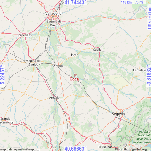
Coca GPS coordinates[2]
41° 13' 3.612" North, 4° 31' 17.22" West
| Map corner | latitude | longitude |
|---|---|---|
| Upper-left | 41.74443°, | -5.22457° |
| Center: | 41.21767°, | -4.52145° |
| Lower-right: | 40.68663°, | -3.81832° |
| Map W x H: | 117.6×117.6 km | = 73.1×73.1mi |
| max Lat: | 43.74134° ⇑46.4% North |
| Coca: | 41.21767° |
| min Lat: | ⇓53.6% South 27.64134° |
| min Long | Coca | max Long |
| -18.00367° | -4.52145° | 4.2899° |
| W 33.6%⇐ | ⇒66.4% E |
Elevation
Elevation of Coca is 789 m = 2589 ft, and this is 191 m = 627 ft above average elevation for this country.
| Max E: |
1682 m = 5518 ft | 33.4% |
| Coca | 789 m 2589 ft | |
| Avg. | 598 m = 1962 ft | |
Min E: |
0 m = 0 ft | 66.6% |
See also: Spain elevation on elevation.city.
Geographical zone
Coca is located in North temperate zone (between Tropic of Cancer and the Arctic Circle). Distance of this Northern Tropic circle is 1977.1 km =1228.5 mi to South.| Distance of | km | miles | from Coca |
|---|---|---|---|
| North Pole | 5424.1 | 3370.4 | to North |
| Arctic Circle | 2818.2 | 1751.1 | to North |
| Tropic Cancer | 1977.1 | 1228.5 | to South |
| Equator | 4583 | 2847.7 | to South |


Nearby cities:
15 places around Coca: (largest is in red/bold)
• Aguasal
12.7 km =7.9 mi,  300°
300°
• Almenara de Adaja
13.1 km =8.1 mi,  268°
268°
• Bocigas
13.4 km =8.3 mi,  276°
276°
• Fresneda de Cuéllar
12.8 km =8 mi,  28°
28°
• Fuente de Santa Cruz
9.6 km =6 mi,  264°
264°
• Llano de Olmedo
9.5 km =5.9 mi,  305°
305°
• Nava de la Asunción
7.4 km =4.6 mi,  157°
157°
• Navas de Oro
7.4 km =4.6 mi,  108°
108°
• Puras
11.4 km =7.1 mi,  250°
250°
• Remondo
14.1 km =8.8 mi,  12°
12°
• Samboal
9.8 km =6.1 mi,  63°
63°
• Santiuste de San Juan Bautista
8.1 km =5 mi,  211°
211°
• Tolocirio
14.3 km =8.9 mi,  229°
229°
• Villaverde de Iscar
9.9 km =6.2 mi,  357°
357°
• Villeguillo
6.2 km =3.9 mi, 308°
Sources, notices
• [Note1] Compared only with cities in Spain existing in our database
• [Src1] Map data: © OpenStreetMap contributors (CC-BY-SA)
• [Src2] Other city data from geonames.org with taken over terms of usage.
• [Src3] Geographical zone / Annual Mean Temperature by Robert A. Rohde @ Wikipedia
