Samboal geodata
Samboal (Castille and León) is a seat of a third-order administrative division; located in Spain in Europe/Madrid (GMT+2) time zone. With population of 547 people, there are 3746 cities with bigger population in this country. Compared to other cities in Spain, 54.5% of cities are located further ↓South; 65.1% of cities are located further →East and 67.5% of cities have lower elevation than Samboal. Note1
Administrative division(s):
- Level 1: Castille and León
- Level 2: Provincia de Segovia
- Level 3: Samboal


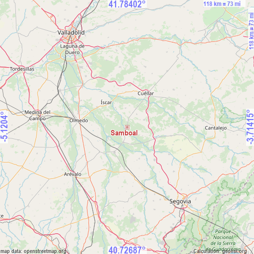
Samboal GPS coordinates[2]
41° 15' 27.288" North, 4° 25' 2.172" West
| Map corner | latitude | longitude |
|---|---|---|
| Upper-left | 41.78402°, | -5.1204° |
| Center: | 41.25758°, | -4.41727° |
| Lower-right: | 40.72687°, | -3.71415° |
| Map W x H: | 117.5×117.5 km | = 73×73mi |
| max Lat: | 43.74134° ⇑45.5% North |
| Samboal: | 41.25758° |
| min Lat: | ⇓54.5% South 27.64134° |
| min Long | Samboal | max Long |
| -18.00367° | -4.41727° | 4.2899° |
| W 34.9%⇐ | ⇒65.1% E |
Elevation
Elevation of Samboal is 795 m = 2608 ft, and this is 197 m = 646 ft above average elevation for this country.
| Max E: |
1682 m = 5518 ft | 32.5% |
| Samboal | 795 m 2608 ft | |
| Avg. | 598 m = 1962 ft | |
Min E: |
0 m = 0 ft | 67.5% |
See also: Spain elevation on elevation.city.
Geographical zone
Samboal is located in North temperate zone (between Tropic of Cancer and the Arctic Circle). Distance of this Northern Tropic circle is 1981.5 km =1231.2 mi to South.| Distance of | km | miles | from Samboal |
|---|---|---|---|
| North Pole | 5419.6 | 3367.6 | to North |
| Arctic Circle | 2813.8 | 1748.4 | to North |
| Tropic Cancer | 1981.5 | 1231.2 | to South |
| Equator | 4587.4 | 2850.5 | to South |


Nearby cities:
15 places around Samboal: (largest is in red/bold)
• Bernardos
15.4 km =9.6 mi,  159°
159°
• Chañe
9 km =5.6 mi,  354°
354°
• Coca
9.8 km =6.1 mi,  243°
243°
• Fresneda de Cuéllar
7.3 km =4.5 mi,  338°
338°
• Gómezserracín
8.4 km =5.2 mi,  64°
64°
• Iscar
15.1 km =9.4 mi,  319°
319°
• Migueláñez
15.8 km =9.8 mi, 163°
• Nava de la Asunción
12.7 km =7.9 mi,  207°
207°
• Navalmanzano
14.2 km =8.8 mi,  108°
108°
• Navas de Oro
7 km =4.3 mi,  193°
193°
• Pinarejos
10.3 km =6.4 mi,  88°
88°
• Remondo
10.8 km =6.7 mi,  329°
329°
• Sanchonuño
11.9 km =7.4 mi,  52°
52°
• Villaverde de Iscar
10.7 km =6.6 mi,  300°
300°
• Villeguillo
13.6 km =8.5 mi,  267°
267°
Sources, notices
• [Note1] Compared only with cities in Spain existing in our database
• [Src1] Map data: © OpenStreetMap contributors (CC-BY-SA)
• [Src2] Other city data from geonames.org with taken over terms of usage.
• [Src3] Geographical zone / Annual Mean Temperature by Robert A. Rohde @ Wikipedia
