Puras geodata
Puras (Castille and León) is a seat of a third-order administrative division; located in Spain in Europe/Madrid (GMT+2) time zone. With population of 62 people, there are 6325 cities with bigger population in this country. Compared to other cities in Spain, 52.7% of cities are located further ↓South; 68% of cities are located further →East and 68.6% of cities have lower elevation than Puras. Note1
Administrative division(s):
- Level 1: Castille and León
- Level 2: Provincia de Valladolid
- Level 3: Puras


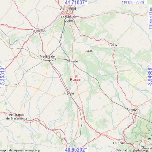
Puras GPS coordinates[2]
41° 10' 59.988" North, 4° 39' 0" West
| Map corner | latitude | longitude |
|---|---|---|
| Upper-left | 41.71037°, | -5.35313° |
| Center: | 41.18333°, | -4.65° |
| Lower-right: | 40.65202°, | -3.94688° |
| Map W x H: | 117.7×117.7 km | = 73.1×73.1mi |
| max Lat: | 43.74134° ⇑47.3% North |
| Puras: | 41.18333° |
| min Lat: | ⇓52.7% South 27.64134° |
| min Long | Puras | max Long |
| -18.00367° | -4.65° | 4.2899° |
| W 32%⇐ | ⇒68% E |
Elevation
Elevation of Puras is 803 m = 2635 ft, and this is 205 m = 673 ft above average elevation for this country.
| Max E: |
1682 m = 5518 ft | 31.4% |
| Puras | 803 m 2635 ft | |
| Avg. | 598 m = 1962 ft | |
Min E: |
0 m = 0 ft | 68.6% |
See also: Spain elevation on elevation.city.
Geographical zone
Puras is located in North temperate zone (between Tropic of Cancer and the Arctic Circle). Distance of this Northern Tropic circle is 1973.2 km =1226.1 mi to South.| Distance of | km | miles | from Puras |
|---|---|---|---|
| North Pole | 5427.9 | 3372.7 | to North |
| Arctic Circle | 2822 | 1753.5 | to North |
| Tropic Cancer | 1973.2 | 1226.1 | to South |
| Equator | 4579.2 | 2845.4 | to South |


Nearby cities:
15 places around Puras: (largest is in red/bold)
• Aguasal
10.2 km =6.3 mi,  358°
358°
• Almenara de Adaja
4.2 km =2.6 mi,  325°
325°
• Bocigas
5.9 km =3.7 mi, 333°
• Coca
11.4 km =7.1 mi,  70°
70°
• Donhierro
8.4 km =5.2 mi,  207°
207°
• Fuente de Santa Cruz
3.2 km =2 mi,  22°
22°
• Llano de Olmedo
9.8 km =6.1 mi, 17°
• Montejo de Arévalo
4.9 km =3 mi,  193°
193°
• Olmedo
12 km =7.5 mi,  344°
344°
• Rapariegos
9.8 km =6.1 mi,  181°
181°
• San Cristóbal de la Vega
7.9 km =4.9 mi, 176°
• San Pablo de la Moraleja
11 km =6.8 mi,  256°
256°
• Santiuste de San Juan Bautista
7.2 km =4.5 mi,  115°
115°
• Tolocirio
5.5 km =3.4 mi, 181°
• Villeguillo
9.7 km =6 mi,  37°
37°
Sources, notices
• [Note1] Compared only with cities in Spain existing in our database
• [Src1] Map data: © OpenStreetMap contributors (CC-BY-SA)
• [Src2] Other city data from geonames.org with taken over terms of usage.
• [Src3] Geographical zone / Annual Mean Temperature by Robert A. Rohde @ Wikipedia
