Oñati geodata
Oñati (Basque Country) is a seat of a third-order administrative division; located in Spain in Europe/Madrid (GMT+2) time zone. With population of 10,896 people, there are 809 cities with bigger population in this country. Compared to other cities in Spain, 94.6% of cities are located further ↓South; 62.1% of cities are located further ←West and 78.4% of cities have higher elevation than Oñati. Note1


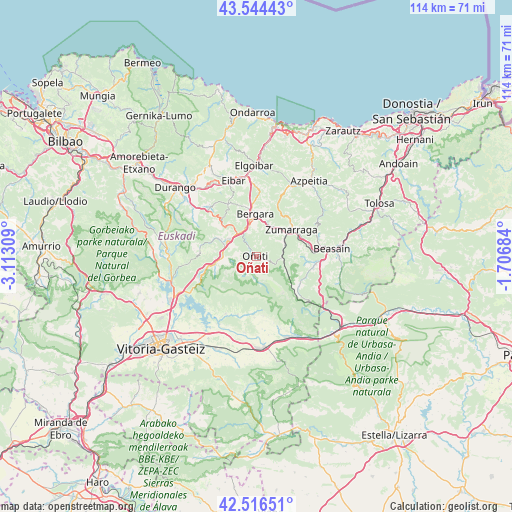
Oñati GPS coordinates[2]
43° 1' 57.432" North, 2° 24' 35.892" West
| Map corner | latitude | longitude |
|---|---|---|
| Upper-left | 43.54443°, | -3.11309° |
| Center: | 43.03262°, | -2.40997° |
| Lower-right: | 42.51651°, | -1.70684° |
| Map W x H: | 114.3×114.3 km | = 71×71mi |
| max Lat: | 43.74134° ⇑5.4% North |
| Oñati: | 43.03262° |
| min Lat: | ⇓94.6% South 27.64134° |
| min Long | Oñati | max Long |
| -18.00367° | -2.40997° | 4.2899° |
| W 62.1%⇐ | ⇒37.9% E |
Elevation
Elevation of Oñati is 248 m = 814 ft, and this is 350 m = 1148 ft below average elevation for this country.
| Max E: |
1682 m = 5518 ft | 78.4% |
| Avg. | 598 m = 1962 ft | |
| Oñati | 248 m = 814 ft | |
Min E: |
0 m = 0 ft | 21.6% |
See also: Spain elevation on elevation.city.
Geographical zone
Oñati is located in North temperate zone (between Tropic of Cancer and the Arctic Circle). Distance of this Northern Tropic circle is 2178.9 km =1353.9 mi to South.| Distance of | km | miles | from Oñati |
|---|---|---|---|
| North Pole | 5222.3 | 3245 | to North |
| Arctic Circle | 2616.4 | 1625.8 | to North |
| Tropic Cancer | 2178.9 | 1353.9 | to South |
| Equator | 4784.8 | 2973.1 | to South |


Nearby cities:
15 places around Oñati: (largest is in red/bold)
• Antzuola
7.6 km =4.7 mi,  18°
18°
• Aretxabaleta
7.7 km =4.8 mi,  271°
271°
• Arrasate / Mondragón
7.4 km =4.6 mi,  298°
298°
• Bergara
9.2 km =5.7 mi,  356°
356°
• Elgeta
13.3 km =8.3 mi,  331°
331°
• Eskoriatza
9.6 km =6 mi,  260°
260°
• Gabiria
10.8 km =6.7 mi,  80°
80°
• Legazpi
6.4 km =4 mi,  68°
68°
• Mutiloa
11.2 km =7 mi,  95°
95°
• Ormaiztegi
12.5 km =7.8 mi, 84°
• Segura
13 km =8.1 mi, 102°
• Urretxu
10 km =6.2 mi,  49°
49°
• Zegama
11.6 km =7.2 mi,  123°
123°
• Zerain
11.4 km =7.1 mi, 101°
• Zumarraga
10 km =6.2 mi, 51°
Sources, notices
• [Note1] Compared only with cities in Spain existing in our database
• [Src1] Map data: © OpenStreetMap contributors (CC-BY-SA)
• [Src2] Other city data from geonames.org with taken over terms of usage.
• [Src3] Geographical zone / Annual Mean Temperature by Robert A. Rohde @ Wikipedia
