Legazpi geodata
Legazpi (Basque Country) is a seat of a third-order administrative division; located in Spain in Europe/Madrid (GMT+2) time zone. In our database, there are 6762 cities with bigger population. Compared to other cities in Spain, 94.9% of cities are located further ↓South; 63% of cities are located further ←West and 65.8% of cities have higher elevation than Legazpi. Note1


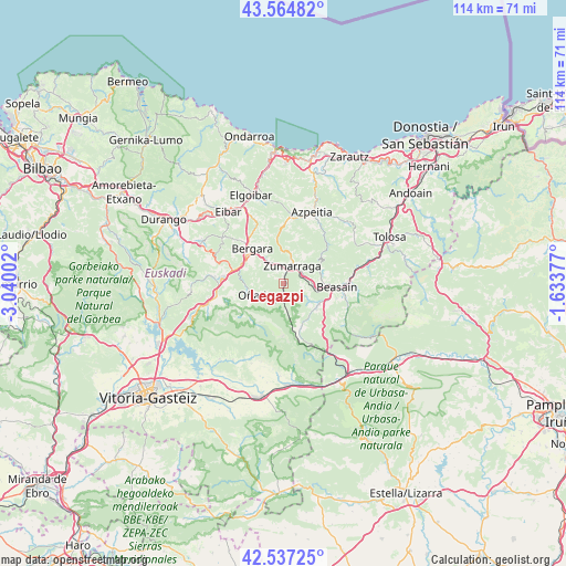
Legazpi GPS coordinates[2]
43° 3' 11.484" North, 2° 20' 12.804" West
| Map corner | latitude | longitude |
|---|---|---|
| Upper-left | 43.56482°, | -3.04002° |
| Center: | 43.05319°, | -2.33689° |
| Lower-right: | 42.53725°, | -1.63377° |
| Map W x H: | 114.3×114.3 km | = 71×71mi |
| max Lat: | 43.74134° ⇑5.1% North |
| Legazpi: | 43.05319° |
| min Lat: | ⇓94.9% South 27.64134° |
| min Long | Legazpi | max Long |
| -18.00367° | -2.33689° | 4.2899° |
| W 63%⇐ | ⇒37% E |
Elevation
Elevation of Legazpi is 448 m = 1470 ft, and this is 150 m = 492 ft below average elevation for this country.
| Max E: |
1682 m = 5518 ft | 65.8% |
| Avg. | 598 m = 1962 ft | |
| Legazpi | 448 m = 1470 ft | |
Min E: |
0 m = 0 ft | 34.2% |
See also: Spain elevation on elevation.city.
Geographical zone
Legazpi is located in North temperate zone (between Tropic of Cancer and the Arctic Circle). Distance of this Northern Tropic circle is 2181.1 km =1355.3 mi to South.| Distance of | km | miles | from Legazpi |
|---|---|---|---|
| North Pole | 5220 | 3243.6 | to North |
| Arctic Circle | 2614.1 | 1624.3 | to North |
| Tropic Cancer | 2181.1 | 1355.3 | to South |
| Equator | 4787.1 | 2974.6 | to South |


Nearby cities:
15 places around Legazpi: (largest is in red/bold)
• Antzuola
6 km =3.7 mi,  324°
324°
• Beasain
11.1 km =6.9 mi,  91°
91°
• Bergara
9.5 km =5.9 mi, 316°
• Gabiria
4.7 km =2.9 mi,  95°
95°
• Idiazabal
9.6 km =6 mi,  118°
118°
• Lazkao
12.5 km =7.8 mi, 100°
• Mutiloa
6.2 km =3.9 mi, 122°
• Olaberria
11.2 km =7 mi, 104°
• Ormaiztegi
6.6 km =4.1 mi, 99°
• Oñati
6.4 km =4 mi,  248°
248°
• Segura
8.4 km =5.2 mi,  127°
127°
• Urretxu
4.5 km =2.8 mi,  21°
21°
• Zegama
9.4 km =5.8 mi,  156°
156°
• Zerain
6.9 km =4.3 mi, 130°
• Zumarraga
4.3 km =2.7 mi,  25°
25°
Sources, notices
• [Note1] Compared only with cities in Spain existing in our database
• [Src1] Map data: © OpenStreetMap contributors (CC-BY-SA)
• [Src2] Other city data from geonames.org with taken over terms of usage.
• [Src3] Geographical zone / Annual Mean Temperature by Robert A. Rohde @ Wikipedia
