Cazalegas geodata
Cazalegas (Castille-La Mancha) is a seat of a third-order administrative division; located in Spain in Europe/Madrid (GMT+2) time zone. With population of 1,458 people, there are 2501 cities with bigger population in this country. Compared to other cities in Spain, 70.1% of cities are located further ↑North; 68.3% of cities are located further →East and 66.3% of cities have higher elevation than Cazalegas. Note1
Administrative division(s):
- Level 1: Castille-La Mancha
- Level 2: Province of Toledo
- Level 3: Cazalegas


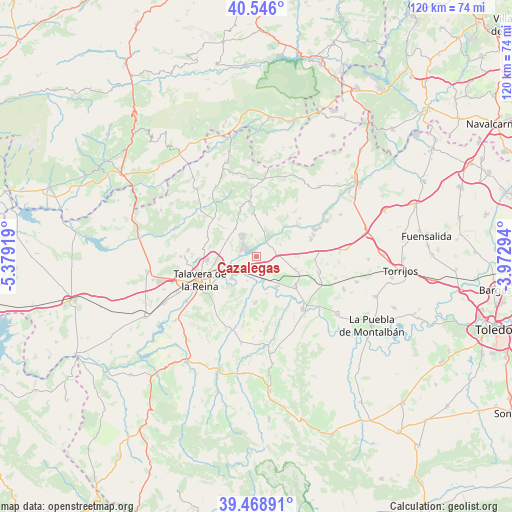
Cazalegas GPS coordinates[2]
40° 0' 34.488" North, 4° 40' 33.816" West
| Map corner | latitude | longitude |
|---|---|---|
| Upper-left | 40.546°, | -5.37919° |
| Center: | 40.00958°, | -4.67606° |
| Lower-right: | 39.46891°, | -3.97294° |
| Map W x H: | 119.8×119.8 km | = 74.4×74.4mi |
| max Lat: | 43.74134° ⇑70.1% North |
| Cazalegas: | 40.00958° |
| min Lat: | ⇓29.9% South 27.64134° |
| min Long | Cazalegas | max Long |
| -18.00367° | -4.67606° | 4.2899° |
| W 31.7%⇐ | ⇒68.3% E |
Elevation
Elevation of Cazalegas is 443 m = 1453 ft, and this is 155 m = 509 ft below average elevation for this country.
| Max E: |
1682 m = 5518 ft | 66.3% |
| Avg. | 598 m = 1962 ft | |
| Cazalegas | 443 m = 1453 ft | |
Min E: |
0 m = 0 ft | 33.7% |
See also: Spain elevation on elevation.city.
Geographical zone
Cazalegas is located in North temperate zone (between Tropic of Cancer and the Arctic Circle). Distance of this Northern Tropic circle is 1842.7 km =1145 mi to South.| Distance of | km | miles | from Cazalegas |
|---|---|---|---|
| North Pole | 5558.4 | 3453.8 | to North |
| Arctic Circle | 2952.5 | 1834.6 | to North |
| Tropic Cancer | 1842.7 | 1145 | to South |
| Equator | 4448.6 | 2764.2 | to South |


Nearby cities:
15 places around Cazalegas: (largest is in red/bold)
• Cardiel de los Montes
6.3 km =3.9 mi,  16°
16°
• Castillo de Bayuela
10.1 km =6.3 mi,  355°
355°
• Cebolla
11.2 km =7 mi,  127°
127°
• Cervera de los Montes
12.4 km =7.7 mi,  292°
292°
• Domingo Pérez
15 km =9.3 mi,  104°
104°
• El Casar de Escalona
13.5 km =8.4 mi,  72°
72°
• El Real de San Vicente
14.1 km =8.8 mi,  354°
354°
• Hinojosa de San Vicente
11.3 km =7 mi,  339°
339°
• Illán de Vacas
11 km =6.8 mi,  113°
113°
• La Pueblanueva
10.8 km =6.7 mi,  181°
181°
• Lucillos
6 km =3.7 mi,  116°
116°
• Montearagón
6.3 km =3.9 mi,  143°
143°
• Nuño Gómez
12.5 km =7.8 mi, 22°
• Otero
13.7 km =8.5 mi,  94°
94°
• Talavera de la Reina
14.1 km =8.8 mi,  248°
248°
Sources, notices
• [Note1] Compared only with cities in Spain existing in our database
• [Src1] Map data: © OpenStreetMap contributors (CC-BY-SA)
• [Src2] Other city data from geonames.org with taken over terms of usage.
• [Src3] Geographical zone / Annual Mean Temperature by Robert A. Rohde @ Wikipedia
