Castillo de Bayuela geodata
Castillo de Bayuela (Castille-La Mancha) is a seat of a third-order administrative division; located in Spain in Europe/Madrid (GMT+2) time zone. With population of 1,103 people, there are 2820 cities with bigger population in this country. Compared to other cities in Spain, 68.8% of cities are located further ↑North; 68.4% of cities are located further →East and 58.5% of cities have higher elevation than Castillo de Bayuela. Note1
Administrative division(s):
- Level 1: Castille-La Mancha
- Level 2: Province of Toledo
- Level 3: Castillo de Bayuela


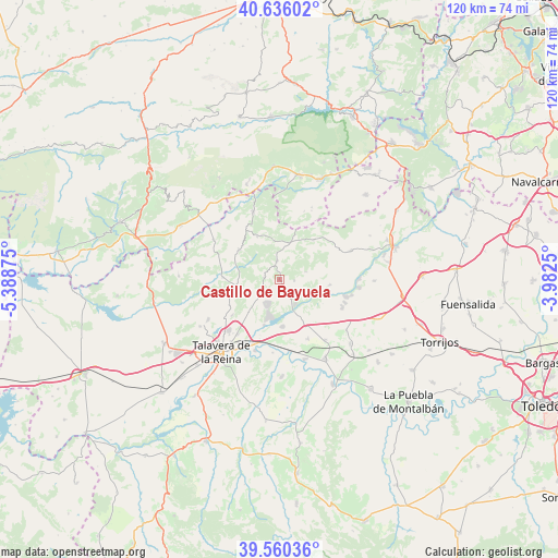
Castillo de Bayuela GPS coordinates[2]
40° 6' 1.152" North, 4° 41' 8.232" West
| Map corner | latitude | longitude |
|---|---|---|
| Upper-left | 40.63602°, | -5.38875° |
| Center: | 40.10032°, | -4.68562° |
| Lower-right: | 39.56036°, | -3.9825° |
| Map W x H: | 119.6×119.6 km | = 74.3×74.3mi |
| max Lat: | 43.74134° ⇑68.8% North |
| Castillo de Bayuela: | 40.10032° |
| min Lat: | ⇓31.2% South 27.64134° |
| min Long | Castillo de Bay | max Long |
| -18.00367° | -4.68562° | 4.2899° |
| W 31.6%⇐ | ⇒68.4% E |
Elevation
Elevation of Castillo de Bayuela is 547 m = 1795 ft, and this is 51 m = 167 ft below average elevation for this country.
| Max E: |
1682 m = 5518 ft | 58.5% |
| Avg. | 598 m = 1962 ft | |
| Castillo de Bayuela | 547 m = 1795 ft | |
Min E: |
0 m = 0 ft | 41.5% |
See also: Spain elevation on elevation.city.
Geographical zone
Castillo de Bayuela is located in North temperate zone (between Tropic of Cancer and the Arctic Circle). Distance of this Northern Tropic circle is 1852.8 km =1151.3 mi to South.| Distance of | km | miles | from Castillo de Bayuela |
|---|---|---|---|
| North Pole | 5548.3 | 3447.6 | to North |
| Arctic Circle | 2942.4 | 1828.3 | to North |
| Tropic Cancer | 1852.8 | 1151.3 | to South |
| Equator | 4458.7 | 2770.5 | to South |


Nearby cities:
15 places around Castillo de Bayuela: (largest is in red/bold)
• Almendral de la Cañada
10.5 km =6.5 mi,  333°
333°
• Cardiel de los Montes
4.9 km =3 mi,  147°
147°
• Cazalegas
10.1 km =6.3 mi,  175°
175°
• Cervera de los Montes
11.9 km =7.4 mi,  243°
243°
• El Casar de Escalona
14.9 km =9.3 mi,  113°
113°
• El Real de San Vicente
3.9 km =2.4 mi,  353°
353°
• Fresnedilla
15.6 km =9.7 mi,  20°
20°
• Hinojosa de San Vicente
3.2 km =2 mi,  278°
278°
• Lucillos
14.2 km =8.8 mi, 154°
• Montearagón
15.8 km =9.8 mi,  163°
163°
• Navamorcuende
10.6 km =6.6 mi,  306°
306°
• Nuño Gómez
5.8 km =3.6 mi,  74°
74°
• Pelahustán
11.2 km =7 mi,  41°
41°
• Sartajada
15.6 km =9.7 mi,  323°
323°
• Sotillo de las Palomas
12.1 km =7.5 mi,  271°
271°
Sources, notices
• [Note1] Compared only with cities in Spain existing in our database
• [Src1] Map data: © OpenStreetMap contributors (CC-BY-SA)
• [Src2] Other city data from geonames.org with taken over terms of usage.
• [Src3] Geographical zone / Annual Mean Temperature by Robert A. Rohde @ Wikipedia
