Otero geodata
Otero (Castille-La Mancha) is a seat of a third-order administrative division; located in Spain in Europe/Madrid (GMT+2) time zone. With population of 227 people, there are 4876 cities with bigger population in this country. Compared to other cities in Spain, 70.2% of cities are located further ↑North; 66.3% of cities are located further →East and 64.6% of cities have higher elevation than Otero. Note1


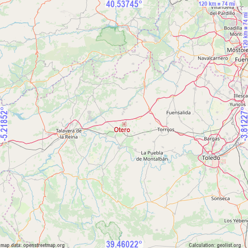
Otero GPS coordinates[2]
40° 0' 3.456" North, 4° 30' 55.404" West
| Map corner | latitude | longitude |
|---|---|---|
| Upper-left | 40.53745°, | -5.21852° |
| Center: | 40.00096°, | -4.51539° |
| Lower-right: | 39.46022°, | -3.81227° |
| Map W x H: | 119.8×119.8 km | = 74.4×74.4mi |
| max Lat: | 43.74134° ⇑70.2% North |
| Otero: | 40.00096° |
| min Lat: | ⇓29.8% South 27.64134° |
| min Long | Otero | max Long |
| -18.00367° | -4.51539° | 4.2899° |
| W 33.7%⇐ | ⇒66.3% E |
Elevation
Elevation of Otero is 465 m = 1526 ft, and this is 133 m = 436 ft below average elevation for this country.
| Max E: |
1682 m = 5518 ft | 64.6% |
| Avg. | 598 m = 1962 ft | |
| Otero | 465 m = 1526 ft | |
Min E: |
0 m = 0 ft | 35.4% |
See also: Spain elevation on elevation.city.
Geographical zone
Otero is located in North temperate zone (between Tropic of Cancer and the Arctic Circle). Distance of this Northern Tropic circle is 1841.8 km =1144.4 mi to South.| Distance of | km | miles | from Otero |
|---|---|---|---|
| North Pole | 5559.4 | 3454.4 | to North |
| Arctic Circle | 2953.5 | 1835.2 | to North |
| Tropic Cancer | 1841.8 | 1144.4 | to South |
| Equator | 4447.7 | 2763.7 | to South |


Nearby cities:
15 places around Otero: (largest is in red/bold)
• Alcabón
12.5 km =7.8 mi,  89°
89°
• Carmena
10.9 km =6.8 mi,  117°
117°
• Carriches
6.3 km =3.9 mi,  130°
130°
• Cebolla
7.5 km =4.7 mi,  219°
219°
• Domingo Pérez
2.8 km =1.7 mi,  162°
162°
• El Carpio de Tajo
13.6 km =8.5 mi, 157°
• El Casar de Escalona
5.1 km =3.2 mi,  350°
350°
• Erustes
5.2 km =3.2 mi, 161°
• Hormigos
12.3 km =7.6 mi,  29°
29°
• Illán de Vacas
4.9 km =3 mi,  226°
226°
• La Mata
9.3 km =5.8 mi,  135°
135°
• Lucillos
8.5 km =5.3 mi,  258°
258°
• Malpica
11.9 km =7.4 mi,  194°
194°
• Montearagón
10.8 km =6.7 mi,  247°
247°
• Santa Olalla
7.7 km =4.8 mi,  70°
70°
Sources, notices
• [Note1] Compared only with cities in Spain existing in our database
• [Src1] Map data: © OpenStreetMap contributors (CC-BY-SA)
• [Src2] Other city data from geonames.org with taken over terms of usage.
• [Src3] Geographical zone / Annual Mean Temperature by Robert A. Rohde @ Wikipedia
